The deepest place in the Amur. Amur as a border river
The Amur River is located in the eastern part of Eurasia. It originates in the mountains of Western Manchuria at an altitude of 303 meters above sea level at the confluence of rivers such as Shilka and Argun. It flows east along the territory of Russia and the Russian-Chinese border. It flows into the Tatar Strait of the Sea of Okhotsk. The length of the river is 2824 km, the basin area is 1.855 million square meters. km. The river basin covers 3 states: Mongolia, Russia and China.
From source to mouth
After the confluence of the Arguni and Shilka, a single river flows east, forming a natural border between China and Russia. Then the river turns southeast. Here it flows through small settlements and receives water from numerous tributaries. Between the cities of Blagoveshchensk (Russia) and Heihe (China), it receives the Zeya River and expands significantly.
Further, the Burei River flows into the Amur, and after 250 km the Sungari River flows through the territory of the People's Republic of China. After this, the river flow turns northeast and continues its path towards the Russian city of Khabarovsk. Here the reunification with the Ussuri River takes place, and the Russian-Chinese border ends.
Then the path continues along a wide valley in Russia. The river bed goes to the northeast. It passes Amursk, Komsomolsk-on-Amur, after which after 200 km the valley narrows noticeably, and the river sharply goes north to its confluence with the Amgun River. After the confluence with the Amgun, the river flow bends sharply to the east, passes Nikolaevsk-on-Amur and flows 20 km downstream into the Tatar Strait.
The river is conventionally divided into 3 sections. The upper section is considered from the source to Blagoveshchensk. The middle section stretches from Blagoveshchensk to Khabarovsk. The lower section flows from Khabarovsk to the mouth. The northern part of the Tatar Strait is called the Amur Estuary. Therefore, we can say that the Amur River flows into the Amur Estuary. This will be absolutely correct.

Amur River on the map
Hydrology
The river is characterized by significant fluctuations in water level. They are caused by summer and autumn monsoon rains. They account for 75% of the annual runoff. Moreover, the difference between the minimum and maximum levels can be 10-15 meters in the upper and middle reaches and up to 8 meters in the lower reaches.
During periods of heavy rainfall, the river can overflow 15-25 km and remain at this level for up to 2 months. Thanks to the construction of hydraulic structures on the Bureya, Zeya and Sungari rivers, floods in summer and autumn have become less pronounced, and in the lower reaches their level does not exceed 6 meters.
Tunnel and bridges
The construction of the first bridge across the river in the city of Khabarovsk was completed in 1916. Its length was 2599 meters. This made it possible for Trans-Siberian Railway trains to cross the water barrier without using ferries. In 1975, a road and railway bridge was built across the Amur River in Komsomolsk-on-Amur. Its length was 1400 meters. In 1999, the Khabarovsky Bridge was reconstructed. In addition to railway traffic, the bridge was opened to vehicular traffic. The second railway track was put into operation in 2009. The total length of the structure was 3890 meters with a width of 25 meters.
The single-track railway tunnel under the Amur was built in 1937-1941. Its length was 7198 meters. In Russia it is the only underwater railway tunnel. It was put into operation in October 1942. At first it was used only by the military, and in 1964 it was opened first for freight trains and then for passenger trains. Currently, the river is crossed by 3 railway tracks: 2 along the Khabarovsky Bridge and 1 through an underwater tunnel.

A train leaves an underwater tunnel
Shipping
The Amur River is navigable along its entire length. Navigation starts from the settlement of Pokrovka, located 4 km downstream from the confluence of the Argun and Shilka, and continues all the way to the Sea of Okhotsk. The movement of private and small vessels is prohibited in border river areas. This is approximately 2 thousand km. Passenger transportation is carried out between China and Russia.
Fauna
The river fauna is considered one of the richest in Russia. There are 130 species of fish here, but only 36 of them are considered commercial. Among the fish we can name black carp, supergazers, silver carp, as well as kaluga, which is the largest representative of sturgeon. Its length can reach 5.6 meters. Sakhalin and Amur sturgeon also live in the water, and salmon fish also spawn. Endemics include kaluga, Chinese perch, snakehead, yellow-cheeked whale, and squeaky killer whale.
Largest tributaries
One of the largest tributaries is Zeya River with a length of 1242 km. In depth and width it exceeds the Amur, but is considered its left tributary. The Zeya hydroelectric power station was built on the river.
Burey River has a length of 623 km. The Bureyskaya hydroelectric power station was built on it. The Songhua River is 1927 km long. It is a right tributary and flows through the territory of the People's Republic of China. The river's flow is regulated by hydroelectric power plants.
Ussuri River with a length of 897 km, it forms a natural border between China and Russia. It is a right tributary, originating in the Sikhote-Alin mountains. Reunites with Amur in the center of Khabarovsk.
Amgun River reaches a length of 723 km. It is a left tributary. In its upper reaches it is a mountain river, and then flows through the taiga lowland. Anyui River has a length of 393 km. It is a right tributary. Flows through a flat swampy area. Forms a wide mouth with ducts and branches.

View of the Amur in Khaborovsk
Ecology
Excess levels of phenol and nitrates are constantly recorded in the Amur River. In the fall of 2005, a Chinese chemical plant discharged toxic substances into the Songhua. After this, a huge spot of nitrobenzene moved downstream. It was stopped by a dam specially built for this purpose. In the summer of 2008, a large oil slick with a diameter of up to 2 km was discovered in the water in the Amur region. Its origin has never been established.
Flood 2013
In the summer of 2013, after long rains, the Amur River overflowed its banks and flooded dozens of settlements in the Khabarovsk Territory, the Amur Region and the Jewish Autonomous Region. The streets of cities such as Blagoveshchensk and Khabarovsk were flooded. Damage was caused to crop fields and hayfields. In total, 192 settlements with thousands of houses and summer cottages were affected.
In Khabarovsk, the water level rose to 8.08 meters in early September. In Komsomolsk-on-Amur, the water level reached 9.1 meters. At the end of the first ten days of September, the water began to recede. By the end of September, the flood rushed into the Tatar Strait, and a massive decline in water began.
River name
The Chinese called the Heilong River Jiang, which translated means “black dragon river.” And the Tungus and Manchus said “Amar”, that is, “big river”. In Mongolian, "black river" is pronounced "Har Moron". Be that as it may, the Russian discoverers named the long and wide river Cupid. It is indicated with this name on maps.
River Amur flows through the territory of the Far East, Mongolia and China. Slightly more than half (54%) of the basin is located in Russia. The Amur River divides the two neighboring states of China and Russia. The basin area of the Amur River basin is 1855 thousand square meters. km. according to this indicator, it ranks fourth among and tenth among the world’s rivers. The length of the river is 2824 km. It feeds primarily on monsoon rains, which account for 75% of its annual flow; feeding on snow plays a secondary role. Because of this, the water level in the riverbed fluctuates by 10-15 meters during floods. During heavy rainfall, the river can overflow 10-20 kilometers. During summer floods, fluctuations in water level do not exceed 3-4 meters.
Along the Amur River
Upper Amur, stretches from the confluence of the Shilka and Argun rivers to the city of Blagoveshchensk, has a length of about 900 kilometers. In the upper reaches the river has a mountainous character and a strong current. Between the Nyukzha ridge and the Greater Khingan, the Amur passes between rocky and high banks. Closer to the city of Blagoveshchensk, the mountains gradually move away and the current slows down.
Middle Amur this is a section of the river between Blagoveshchensk and Khabarovsk with a length of about 1000 km. In this section, the river flows in a wide valley, the banks are swampy in places and there are numerous river flows. After crossing the Lesser Khingan, the Amur valley narrows and its waters gather into one powerful stream flowing in a picturesque valley.
Lower Amur, this is a section from Khabarovsk to the sea, about 950 km long. Here the river flows through the vast Lower Amur Lowland, where there are many lakes and oxbow lakes. After the city of Nikolaevsk there is the Amur Estuary, through which it connects with the Tatar Strait. After the confluence of a large tributary of the tributary - the Ussuri, the Amur becomes especially full-flowing.
Tributaries
Zeya, Ussuri, Bureya, Sungari, Argun, Anyui. Gorin, Gur, Amgun
Fishery resources
Amur is one of the largest fishing areas in Russia. The most valuable fish are Chum salmon, Salmon, Pink salmon, Smelt, Lamprey. In addition, the river is home to such rare species of fish as Kaluga and sea sturgeon.
Briefly
Main characteristics of the Amur River:
Length - 2824 km.
Swimming pool - 2855 sq. km.
Annual flow – 11330 cubic meters/s
The greatest width is 5 km (Troitskoye village)
The greatest depth is 56 m (near the Tyrsky cliff)
Food - mainly rain
Interesting Facts:
- The first Russians appeared on the Amur in 1644, then the Cossacks came there under the leadership of V. Poyarkov.
- Every year, exceedances of MPCs for microbiological indicators, nitrates and phenol are recorded in the river.
- The Amur River basin is located on the territory of 3 countries - Russia (about 54%), China (44%) and Mongolia (2%).
Photo of cupid:
 |
 |
 |
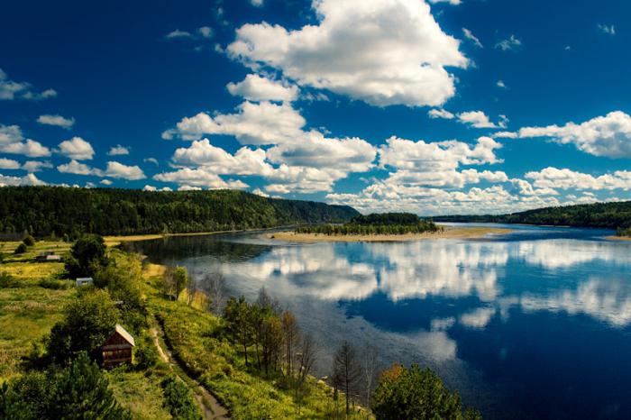
None of the residents of the Far Eastern region will argue that their main river is the Amur. It is in fourth place among the rivers of the Russian Federation, second in length only to such majestic streams as the Ob, Yenisei and Lena. The mouth of the Amur - the Sea of Okhotsk.
a brief description of
A water flow is formed due to the confluence of Arguni and Shilka. The place where it originates, up to Khabarovsk, is considered the border between two countries: Russia and China. The slope of the riverbed is no more than 0.11%. The source and Amur stretch for 2850 km. Sometimes one of the constituent rivers, the Shilka, is taken as the starting point, in which case the length of the water flow will be 4510 km. However, these values may not be entirely accurate, since the measurement process is quite complex. The basin area, including the Kerulen River, is 2 million square meters. km. Throughout the water flow, characteristic differences can be observed. For example, its valley is divided into three parts: lower, middle, upper. Each of these sections has certain dimensions of the depth and width of the channel, as well as the nature of the flow. The height of the mouth of the Amur River (as well as the height of the sea) is 0 m, while the source is 304 m above sea level.

Geography
The entire basin of the water flow is located in It covers four natural zones at once: forest, steppe, forest-steppe, semi-desert. Every year about 300 mm of precipitation falls, the same amount of which flows into the source and mouth of the Amur River; in the area of the Sikhote-Alin ridge, in particular in its southeastern part, this number increases to 750 mm.

The river basin covers several states at once - Russia (54%), China (44%), Mongolia (1%). The part of the Amur, which is located in the Russian Federation, is divided into the Far Eastern region and the Siberian region.
Hydrology
The mouth of which is located in the city of Nikolaevsk-on-Amur, is divided into three sections:
- Lower. Stretches for 966 km. Has industrial significance. It is located in the area of the mouth of the Ussuri up to Nikolaevsk-on-Amur. The current speed in this interval reaches 4 km/h, this allows you to successfully engage in fishing not only for personal purposes, but also for sale.
- Average. Captures the area from Zeya to Ussuri. Length more than 970 km. The banks in this area are densely covered with vegetation. The movement of water in the stream is on average about 5 km/h. The channel in this area is quite wide and deep, which facilitates the development of navigation.
- Upper. It stretches to the mouth and occupies about 880 km. Famous for its diversity of flora and fauna. You can often meet representatives of salmon. Current speed - 5 km/h.
Water consumption for the year is 9819 m 3 /s, mainly these data take into account consumption in the city of Komsomolsk, where the Amur River flows. The mouth consumes much more - 11,400 m 3 /s.

The uniqueness and peculiarity of the water flow is that the water level in it is constantly changing due to rain. As a rule, they account for more than 70% of the runoff. During the summer low-water period, the water level drops to 15 m in the upper as well as in the middle section of the Amur; in the lower, the height reaches a record decline - up to 8 m. In some zones, the flow spreads over a distance of up to 25 km. This is mainly due to the characteristic climatic conditions, in particular constant heavy rains. This state of the river can last almost 2-3 months. At the moment, after numerous waterworks have been built, floods are less pronounced, and the water level fluctuates around 6 m.
Ecology
In this water stream, the indicators of harmful substances are too high and can be dangerous both for the environment and for human health. In 2005, an accident occurred at a Chinese factory, causing toxic chemicals to be released into the Songhua. This incident had a negative impact on the ecological condition of the rivers that have common tributaries. Along one of them, gasoline, nitrobenzene and other substances were brought to the Amur by the current. For a long time they lay in huge spots on the surface of its waters. Phenol, nitrates and other microbiological particles - all this is contained in the Amur River. The estuary, whose waters are quite heavily polluted, is on the verge of an environmental disaster. In order to protect water in the Khabarovsk region, a dam was built. This made it possible to change the movement of the river and send all chemical pollution to the northern bank, which is located in Russia. A year later, the dam was partially dismantled, as there was no longer any urgent need for it.

3 years after the accident at the plant, in 2008, residents of coastal areas discovered an oil slick, the size of which reached an average of 2 km. However, no matter how hard scientists tried, its origin could not be established.
The Amur River, whose mouth is rich in tributaries, has several watercourses:
Recently, an opinion has emerged that the Amur is a tributary of the Zeya, and not vice versa. Thanks to images from space, you can understand that it is much deeper and wider. From a geological point of view, its valley is a continuation of the Amur (if you look in the south-north direction). However, the source remote from the mouth is located thanks to the traditional method - through Argun and Amur. Therefore, the width and fullness of the river are rarely taken into account when determining tributaries.
The Amur River flows in East Asia.
At one time, different countries called it in their own way. Since ancient times, the Chinese called it the black dragon river or “Heilong Jiang”, the Manchus - “Amar”, the Mongols - the black river “Har Moron”.
The name Amur was given by the Russians and has stuck better than ever before.
Source
The beginning of the river in the mountains of Manchuria. At approximately three hundred three meters above sea level, the Argun and Shilka rivers merge into one, and they are the source of the Amur. Flows in an easterly direction.
 sunset. Amur river photo
Most scientists believe it flows into the Tatar Strait of the Sea of Okhotsk, although there is a different opinion. Some researchers insist that it flows into the Sea of Japan.

Amur river photo
The upper part of the Tatar Strait is also called the Amur Estuary, therefore in many textbooks and books you can find a mention that the Amur flows into the Amur Estuary. This is also a completely correct statement.
Characteristics
The Amur is 2824 km long and passes through three countries: Russia, China and Mongolia. The latter only affects her a little. The area of the river basin is 1.855 million square kilometers, which is the fourth largest in Russia and 10th among the rivers of the entire planet. The current varies at different intervals, ranging from 4.2 to 5.5 km/h.

Amur river photo
It is conditionally divided into three sections. The upper one is considered from the source to Blagoveshchensk, the middle one - from Blagoveshchensk to Khabarovsk and the lower one - from Khabarovsk to the mouth. The basin passes through temperate latitudes. Along its length it affects 4 physical-geographical zones: steppe, forest-steppe, semi-desert and forest.
River mode
Water levels can fluctuate greatly throughout the year. This is primarily due to monsoon rains. Depending on the seasons, in the upper and middle sections the difference between the maximum and minimum water often reaches from 10 to 15 meters, and in the lower section - 8 meters. Recently, scientists have taken up the issue of river flooding during the rainy season.

Amur river nature photo
In summer, the most frequent spills are observed, associated with large amounts of precipitation; the same picture is observed in spring, when ice and snow melt. Its annual flow also depends on the water regime of the Amur. There are four different types of flow in the Amur: low, low, moderate and high.

Khabarovsk. Amur River photo
The river is fed primarily by rain and downpours. Snow can feed it only if there are heavy snowfalls, and this is not recorded every year.
Flora and fauna
There are more than 136 species of fish, among them: silver carp, kaluga, aukha, rotan, white and black carp, and so on. Among them, no more than 40 are considered commercial. The rest are either not of particular interest for fishing or are protected by law. There are also endemic fish: killer whale, yellowjacket, snakehead, kaluga, Chinese perch.
Cities
Along its course, the Amur crosses many cities. Among them are Khabarovsk, Blagoveshchensk, Komsomolsk-on-Amur, Amursk, Nikolaevsk-on-Amur, Heihe.
Tributaries
Flowing through numerous settlements, the Amur takes water from various tributaries. The Zeya, Burey, Sungari, Ussuri, and Amgun rivers also flow into it. The largest of the tributaries is the Zeya. Its peculiarity is that it is deeper and wider than the Amur, although it is its left tributary. The right tributary is considered to be the Bureya, which flows in China.
The Ussuri River is the second right tributary, as well as the natural border of Russia and China. The Amgun and Anyui rivers are left and right tributaries, respectively.
Tourism on the river
Navigation is permitted and observed along the entire length of the river. The restriction of movement applies only to private and small vessels only in border areas. Moreover, this restriction applies only to Russia; there are no such restrictions from China. Passenger transportation is regularly carried out between China and Russia.
It is actively used for fishing, hydroelectric power stations, timber rafting, recreation, and tourism. Tourists travel on ships and boats in search of amazing places and beautiful landscapes.
- The first working, large bridge across the Amur was erected in 1916. Its length is 2599 meters.
- Under the river there is a single-hull railway tunnel 7198 meters long. It was built in 1937-1941. It is the only underwater tunnel in Russia. Due to the release of various chemical wastes from plants and factories into the water, the ecology of the Amur River leaves much to be desired. Elevated levels of phenol and nitrates are regularly recorded.
- For many years there has been debate about whether the Zeya is a tributary or a river to which the Amur adjoins.
But what about our native rivers? We at TravelAsk decided to talk about the TOP 5 widest and mightiest rivers of our Motherland.
Generally speaking, narrow rivers are those whose width is less than 60 meters, medium - up to 150 meters. Well, the big ones are all rivers that stretch more than 150 meters in width. But there are giants in our country, the width of which is measured in kilometers. Of course, reservoirs reach their maximum parameters in the spring, during the flood period, when the river overflows its banks. The area of a river valley that is periodically flooded is called a floodplain. This is what we based our rating on.
Ob (60 kilometers)
The Ob is not only the widest river in Russia, but also. In the Khanty-Mansiysk region it merges with its tributary the Irtysh, where during flood periods it forms a huge floodplain up to 60 kilometers wide. By the way, downstream the Ob is even wider and forms an estuary (the mouth of a river that expands towards the sea) up to 80 km wide. It was named the Gulf of Ob.

Some facts about Obi:
Fact #1. The area of the Ob basin is five times larger than France.
Fact #2. The Ob has many names (they were given by different peoples who lived on its banks), but almost all of them mean “big river”.
Fact #3. In the warm season, at the source of the Ob, it is striped. This is due to the fact that the rivers Biya and Katun, which form it, carry waters of different colors. The water does not mix immediately, which is why this effect is created.
Amur (40-50 kilometers)

The Amur is divided into three parts: to Blagoveshchensk - Upper Amur, from Blagoveshchensk to Khabarovsk - Middle Amur, below Khabarovsk - Lower Amur. So, during severe floods, the latter merges with lakes Sindinskoye, Petropavlovskoye, Hummi and Kizi and turns into a reservoir of gigantic proportions, in some places its width reaches 40-50 meters. Amur spills are dangerous: they can sweep away everything in their path. Remember the flood of 2013, when 185 settlements were flooded.

Some facts about Amur:
Fact #1. The Amur flows through the territory of China and Russia. In China it is called "Heihe", which translates as "black river".
Fact #2. About 130 species of fish live in the Amur. Not a single river in Russia can boast of such quantity. The most famous of its inhabitants: two species of sturgeon, kaluga (it reaches gigantic sizes) and 9 species of salmon.
Fact #3. The five thousand dollar bill depicts the Amur Bridge, which crosses the river.

Lena (20-30 kilometers)

The Lena turns into a giant after Yakutsk: below the city the Aldan and Vilyui flow into it. And after this, the river in some places expands to 20-30 kilometers. Tourists come to admire this river and nature. The landscapes here are truly amazing, and the Lena Pillars have become famous far beyond the borders of Russia.

Some facts about Lena:
Fact #1. During the spring flood, the level of the Lena can rise by 10-15 meters. For this reason, its shores are not inhabited.
Fact #2. The Lena is the largest of the Russian rivers flowing through the country from source to mouth.
Fact #3. The Lena is the only river in the world whose entire bed is in the permafrost zone.
Volga (15-25 kilometers)

It is located near Krasnoarmeysk: here the spill reaches 27 kilometers. At the borders of the Volgograd region during the flood period, the width can be up to 10.5 kilometers. This territory was named the Volga-Akhtuba floodplain.
Some facts about the Volga:
Fact #1. The reservoirs “shortened” the Volga by 160 kilometers.
Fact #2. Pelicans and flamingos live on the Volga, and lotuses also grow.
Fact #3. The Volga is considered the birthplace of barge haulers. About 600 thousand people worked here during the season.
Kama (about 20 kilometers)

The Kama has a huge floodplain, in some places reaching a width of 20 kilometers. This section stretches approximately 59 kilometers from the mouth of the Belaya River to the mouth of the Ik.
Some facts about Kama
Fact #1. In Russia it is believed that the Kama is a tributary of the Volga. However, this happened due to the fact that the Volga played a huge role in the creation of a unified Russian state. But from the point of view of geology, the opposite is true: the Volga flows into the Kama.


Moreover, the Kama is an older river: it was the one that flowed into the Caspian Sea before the Ice Age, and the Volga was generally a tributary of the Don. Well, after the Cheboksary reservoir was launched on the Volga in 1983, it turned into a cascade of large flowing lakes. And on the Kama, in turn, there are much fewer dams, and the natural river bed has been preserved here. Therefore, there is an eternal dispute: who is more important - the Volga or the Kama?
Fact #2. Today the length of the Kama is 1805 kilometers. The Kuibyshev reservoir “ate” more than 200 kilometers.
Fact #3. About 75 thousand rivers flow into the Kama, mostly small rivers not exceeding 10 kilometers in length.