Deadly danger at sea: reverse flow. Black Sea
Many people who swim well or float well on the water do not understand how you can drown near the shore. Hearing the holiday news bulletins of tourists “killed off the coast,” they think the victims either did not know how to swim or were drunk. But they are wrong. What then is the reason?
We are talking about a very dangerous, but little-known phenomenon - rip currents, which are often also called "rips" and "rips" (English - rip current). There are rip currents in all corners of the planet and in the Gulf of Mexico, and on the Black Sea, and on the island of Bali. These insidious rips can be difficult not only for ordinary people, but also for first-class swimmers who do not know how to behave in this situation.
Everything happens unexpectedly: here you swam from the coast, and then turned back, but nothing happens ... You swim with all your might, but stay in one place or even move further away. All attempts are unsuccessful, your strength is running out and you are close to panic ...
First, it's important to understand how rip works. This is a type of marine and ocean currents directed at right angles to the coast and formed in the process of the flow of tidal water flowing towards the sea.
The most dangerous are the rip currents in shallow seas with a gentle coast, which is framed by sandbanks, spits and islets (the Sea of Azov, etc.). In these places, at low tide, the return of the mass of water to the sea is prevented by sand spits. The water pressure on the narrow strait connecting the sea with the estuary increases many times over. As a result, a fast stream is formed, along which water moves at a speed of 2.5-3.0 m / s.

These "corridors" appear in different places near the coast during high tides. The waves roll in and bring water mass, and then with different speed go into the sea or ocean, while forming a reverse current. This is observed in areas where ebb and flow often occur.
In the attached photo with a red arrow, the streams of seething water are not so noticeable, but the current itself and the people caught in it are clearly visible.

Most often, the rip width is 2-3 m, and the current speed is 4-5 km / h, which is not dangerous.
But from time to time there are "draft" widths up to 50 m, length up to 200-400 m and a speed of up to 15 km / h! This happens much less frequently. But it happens!
How do you learn to distinguish places where there are rips so as not to get into them? First of all Look for the following telltale signs:
The visible channel of seething water is perpendicular to the shore;
- V coastal zone there are areas with a different shade of water: for example, everything around is light blue or greenish, and some area is white. Areas with foam, moving algae and bubbles that move from the coast to the open sea;
- The continuous strip of tidal waves has a 5-10-meter gap;
If you notice any of the above, never swim in this place. But the danger is that 80% of sudden rips do not externally manifest themselves. It is in their "tenacious paws" that most tourists fall. Only professional rescuers can identify such areas.
It is important to remember that rip currents often occur near the coast, so they are able to pull even people standing in the water up to their waist or chest. And if swimmers have great chances to escape, then people who cannot swim have critically few of them. Therefore, do not swim alone or enter places that seem suspicious to you.
Choose lively beaches where lifeguards are on duty.
- And always look out for red flags and signs on the beach where swimming is strictly prohibited. This is not a joke!
And the most important point! How to behave to those who are caught in such a course?
Rules of conduct in the rip current

1. Overcome your panic! Pull yourself together, because people, knowledgeable rules behavior in rip, are saved in 99% of cases.
2. Save your strength! You do not need to row with all your strength against the current, losing energy reserves. You need to swim not to the shore, but to the side, parallel to the beach. If the rip is narrow (up to 5 m), you will get out of it very quickly.
3. Analyze! If you row according to the rules - to the side, but you can't get out, then the rip is wide (from 20 m and more). Then we immediately stop wasting energy and panic! The reverse flow is usually short and after 3-4 minutes it will stop. After that, sail 50-100 m to the side, and only then return to the shore with respite.
And the following facts will help you avoid panic:
Rip will not drag you to the bottom. Most often, rip currents are short and the upper layer of water moves at high speed, which supports floating objects.
The rip is not very wide. Its width does not exceed 50 m. And in most cases it is only 10-20 m. As a result, swimming along the coast literally 20-30 m, you will notice that you have swum out of the rip.
The rip length is limited. The current weakens rather quickly, the "draft" loses its strength where the waves reach their peak and begin to break. In surfer slang, this place is called "line up" (line up). All surfers who are preparing to conquer the incoming waves gather in it. Usually the "line-up" is located no further than 100 m from the coast.
Located in the interior of the continent, the Black Sea (together with the Azov Sea) is the most isolated part of the World Ocean. In the southwest, it communicates with the Sea of Marmara through the Bosphorus, the border between the seas runs along the line of Cape Rumeli - Cape Anadolu. The Kerch Strait connects the Black and Azov sea, the border between which is the line of Cape Taquil - Cape Panagia.
The area of the Black Sea is 422 thousand km 2, the volume is 555 thousand km 3, the average depth is 1315 m, greatest depth- 2210 m.
The coastline, with the exception of the north and northwest, is poorly indented. The eastern and southern shores are steep and mountainous, the western and northwestern ones are low and flat, steep in places. The only large peninsula is the Crimean one. In the east, the spurs of the Greater and Lesser Caucasus ranges, separated by the Colchis lowland, come close to the sea. The Pontine Mountains stretch along the southern coast. In the Bosphorus region, the shores are low, but steep, in the southwest the Balkan Mountains approach the sea, further to the north is the Dobrudja Upland, which gradually turns into the low-lying areas of the vast Danube delta. The northwestern and partly northern shores up to the mountainous southern coast of Crimea are low, dissected by gullies, vast estuaries at river mouths (Dniester, Dnieper-Bug), fenced off from the sea by spits.
The coast in the Pitsunda area
In the northwestern part of the sea there are the largest bays - Odessa, Karkinitsky, Kalamitsky. In addition to them, on the southern coast of the sea there are Samsun and Sinop bays, on the west - Burgas. Small islands Zmeiny and Berezan are located in the northwestern part of the sea, Kefken - to the east of the Bosphorus.
The main part of the river runoff (up to 80%) enters the northwestern part of the sea, where the waters carry the most large rivers: Danube (200 km 3 / year), Dnieper (50 km 3 / year), Dniester (10 km 3 / year). On the Black sea coast In the Caucasus, the Inguri, Rioni, Chorokh and many small rivers flow into the sea. On the rest of the coast, runoff is negligible.
Climate
Far from the ocean, surrounded by land, the Black Sea is characterized by a continental climate, which is manifested in large seasonal changes in air temperature. On the climatic features individual parts of the sea are significantly influenced by orography - the nature of the relief of the coastal strip. So, in the northwestern part of the sea, open to the impact air masses from the north, the steppe climate is manifested ( Cold winter, roast, dry summer), and in a protected high mountains southeastern part - the climate of humid subtropics (abundance of precipitation, warm winter, wet summer).
In winter, the sea is affected by the spur of the Siberian anticyclone, causing the invasion of cold continental air. They are accompanied by northeasterly winds (at a speed of 7 - 8 m / s), often reaching stormy force, sharp drops in air temperature, and precipitation. Particularly strong northeastern winds are typical for the Novorossiysk region (bora). Here masses of cold air accumulate behind the high coastal mountains and, having passed over the peaks, collapse with great force down to the sea. The wind speed during the bora reaches 30-40 m / s, the frequency of the bora is up to 20 or more times a year. When the spur of the Siberian anticyclone weakened in winter, Mediterranean cyclones emerge onto the Black Sea. They cause erratic weather with warm, sometimes very strong southwest winds and temperature fluctuations.
In summer, the influence of the Azores maximum spreads to the sea, clear, dry and hot weather sets in, thermal conditions become uniform for the entire water area. In this season, weak north-westerly winds (2-5 m / s) prevail, only in rare cases in coastal strip In the northeastern part of the sea, northeastern winds of storm force arise.
The most low temperature in January - February it is observed in the northwestern part of the sea (–1–5 °), on the southern coast of Crimea it rises to 4 °, and in the east and south - to 6–9 °. Minimum temperatures in the northern part of the sea they reach -25 - 30 °, in the southern part -5 - 10 °. In summer, the air temperature is 23 - 25 °, the maximum values at different points reach 35-37 °.
Precipitation on the coast is very uneven. In the southeastern part of the sea, where Caucasian ridges block the path of the western and southwestern moist Mediterranean winds, falls the largest number precipitation (in Batumi - up to 2500 mm / year, in Poti - 1600 mm / year); on the flat north-western coast only 300 mm / year, on the southern and western coasts and on the southern coast of Crimea - 600-700 mm / year. Through the Bosphorus, 340-360 km 3 of the Black Sea water flows annually, and about 170 km 3 of Mediterranean water flows into the Black Sea. Water exchange through the Bosphorus is subject to seasonal changes, determined by the difference in the levels of the Black and Marmara Seas and by the nature of the winds in the area of the strait. The Upper Bosporus current from the Black Sea (occupying a layer of about 40 m at the entrance to the strait) reaches its maximum in summer, and its minimum is observed in autumn. The intensity of the lower Bosporus current into the Black Sea is greatest in autumn and spring, and least of all - at the beginning of summer. In accordance with the nature of wind activity over the sea, strong waves most often develop in autumn and winter in the northwestern, northeastern and central parts of the sea. Depending on the wind speed and wave acceleration length in the sea, waves with a height of 1-3 m prevail. In open areas maximum heights waves reach 7 m, and at very strong storms may be higher. The southwestern and southeastern parts of the sea are the calmest, strong waves are rarely observed here, and there are almost no waves over 3 m in height.

Crimean coast
Seasonal changes in sea level are mainly due to intra-annual differences in river flow inflow. Therefore, in the warm season, the level is higher, in the cold season, it is lower. The magnitude of these fluctuations is not the same and is most significant in areas affected by continental runoff, where it reaches 30-40 cm.
The highest value in the Black Sea is observed for surge level fluctuations associated with the impact of stable winds. They are especially often observed in the autumn-winter time in the western and northwestern parts of the sea, where they can exceed 1 m. In the west, strong surges cause east and northeastern winds, and in the northwest, southeastern winds. Strong surges in the indicated parts of the sea occur with north-westerly winds. At the Crimean and Caucasian coasts, surges and surges rarely exceed 30-40 cm. Usually their duration is 3-5 days, but sometimes it can be longer.
In the Black Sea, seiche level fluctuations with a height of up to 10 cm are often observed. Seiches with periods of 2-6 hours are excited by the influence of the wind, and 12-hour seiches are associated with tides. The Black Sea is characterized by irregular semi-diurnal tides.
Ice cover
Ice forms annually only in a narrow coastal strip of the northwestern part of the sea. Even in harsh winters it covers less than 5%, and in mild winters- 0.5-1.5% of the sea area. In very severe winters, fast ice extends along the western coast to Constanta, and floating ice is carried to the Bosphorus. Over the past 150 years, ice floes in the strait have been observed 5 times. In mild winters, only estuaries and individual bays are covered with ice.
Ice formation usually begins in mid-December, and the maximum distribution of ice is observed in February. The boundary of stationary ice in moderate winters in the northwestern part of the sea runs from the Dniester estuary to the Tendrovskaya Spit at a distance of 5-10 km from the coast. Further, the ice edge crosses the Karkinitsky Bay and reaches the middle part of the Tarkhankutsky Peninsula. Cleansing of the sea from ice occurs in March (early - in early March, later - in early April). The duration of the ice period varies greatly: from 130 days in very severe winters to 40 days in mild winters. The ice thickness does not exceed 15 cm on average; in severe winters it reaches 50 cm.
Bottom relief

Underwater canyon in the Black Sea
Three main structures are clearly distinguished in the relief of the seabed: the shelf, the continental slope, and the deep-water basin. The shelf occupies up to 25% of the total bottom area and, on average, is limited to a depth of 100-120 m. It reaches its greatest width (more than 200 km) in the northwestern part of the sea, which is all located within the shelf zone. Almost along the entire length of the mountainous eastern and southern shores of the sea, the shelf is very narrow (only a few kilometers), and in the southwestern part of the sea it is wider (tens of kilometers).
The continental slope, which occupies up to 40% of the bottom area, descends to a depth of 2000 m. It is steep and indented by underwater valleys and canyons. The bottom of the basin (35%) is a flat accumulative plain, the depth of which gradually increases towards the center.
Water circulation and flow
The water circulation throughout the year has a cyclonic character with cyclonic gyres in the western and eastern parts of the sea and the main Black Sea alongshore current enveloping them. Seasonal changes in circulation are manifested in the velocities and in the details of this system of currents. The main Black Sea current and cyclonic gyres are most pronounced in winter and summer. In spring and autumn, water circulation becomes weaker and more complex in structure. In the southeastern part of the sea, a small anticyclonic gyre forms in summer.
In the water circulation system, three characteristic regions can be distinguished, the structure of currents in which is distinguished by its originality: the coastal part, the zone of the main black sea current and open parts of the sea.
The boundaries of the coastal part of the sea are determined by the width of the shelf. The current regime here depends on local factors and is significantly variable in space and time.
The zone of the main Black Sea current, 40-80 km wide, is located above the continental slope. The currents in it are very stable and have a cyclonic direction. The velocities of currents on the surface are 40-50 cm / s, sometimes they exceed 100 and even 150 cm / s (in the streamline). In the upper 100-meter layer of the main current, the velocities decrease slightly with depth, the maximum vertical gradients fall on a layer of 100-200 m, below which the velocities slowly decay.
In the open parts of the sea, the currents are weak. Average velocities here do not exceed 5-15 cm / s on the surface, slightly decreasing with depth up to 5 cm / s at horizons of 500-1000 m. The boundaries between the indicated structural areas are rather arbitrary.
In the shallow northwestern part of the sea, circulation is mainly driven by wind. The north and north-east winds determine the cyclonic nature of the currents, while the western winds are anticyclonic. In accordance with the nature of the winds, the establishment of anticyclonic circulation is possible in the summer season.
The general circulation of sea waters has a unidirectional character down to a depth of about 1000 m. In deeper layers it is very weak, and it is difficult to talk about its general character.
An important feature of the main Black Sea current is its meandering, which can lead to the formation of isolated eddies that differ in temperature and salinity from the surrounding waters. The dimensions of the eddies reach 40-90 km; the phenomenon of eddy formation is essential for water exchange not only in the upper, but also in the deep layers of the sea.
Inertial currents with a period of 17-18 hours are widespread in the open sea. These currents have an effect on mixing in the water column, since their velocities even in a layer of 500-1000 m can be 20-30 cm / s.
Water temperature and salinity
The water temperature on the sea surface in winter rises from -0.5-0 ° in the coastal regions of the north-western part to 7-8 ° in central regions and 9-10 ° in the southeastern part of the sea. In summer, the surface water layer warms up to 23-26 °. Only during surges can there be short-term significant drops in temperature (for example, near the southern coast of Crimea). During the warming up of the sea, at the lower boundary of wind mixing, a layer of temperature jump is formed, which limits the spread of heat by the upper homogeneous layer.
Salinity on the surface is minimal throughout the year in the northwestern part of the sea, which receives the bulk of river waters. In the estuarine areas, salinity increases from 0-2 to 5-10 ‰, and in most of the water area open sea it is equal to 17.5-18.3 ‰.
In the cold season, vertical circulation develops in the sea, by the end of winter covering a layer with a thickness of 30-50 m in the central to 100-150 m in the coastal regions. Waters are cooled most strongly in the northwestern part of the sea, from where they spread by currents at intermediate horizons throughout the sea and can reach the regions farthest from cold centers. As a consequence of winter convection, with the subsequent summer warming up, a cold intermediate layer is formed in the sea. It persists throughout the year at horizons of 60-100 m and stands out in temperature at the boundaries of 8 °, and in the core - 6.5-7.5 °.
Convective mixing in the Black Sea cannot spread deeper than 100-150 m due to an increase in salinity (and, consequently, density) in deeper layers as a result of the inflow of salty marble sea waters there. In the upper mixed layer, salinity increases slowly, and then sharply increases by 100-150 m from 18.5 to 21 ‰. This is a permanent salinity jump layer (halocline).
Starting from horizons of 150-200 m, salinity and temperature slowly rise to the bottom due to the influence of the saltier and warmer marble sea waters entering the deep layers. At the exit from the Bosphorus, they have a salinity of 28-34 ‰ and a temperature of 13-15 °, but quickly change their characteristics, mixing with the Black Sea water. In the bottom layer, a slight increase in temperature also occurs due to the geothermal inflow of heat from the bottom of the sea. Deep waters, located in a layer from 1000 m to the bottom and occupying more than 40% of the sea volume in the Black Sea in winter (II) and summer (VIII), are characterized by high constancy of temperature (8.5-9.2 °) and salinity (22- 22.4 ‰.

Vertical distribution of water temperature (1) and salinity (2)
Thus, the main components are distinguished in the vertical hydrological structure of the Black Sea waters:
upper homogeneous layer and seasonal (summer) thermocline associated mainly with the process of wind mixing and annual cycle heat flux across the sea surface;
a cold intermediate layer with a minimum temperature in depth, which in the north-west and north-east of the sea arises as a result of autumn-winter convection, and in other regions is formed mainly by the transfer of cold waters by currents;
permanent halocline - a layer of maximum salinity increase with depth, located in the contact zone of the upper (Black Sea) and deep (Marble Sea) water masses;
deep layer - from 200 m to the bottom, where there are no seasonal changes in hydrological characteristics, and their spatial distribution is very homogeneous.
The processes occurring in these layers, their seasonal and interannual variability, determine the hydrological conditions of the Black Sea.
The Black Sea has a two-layer hydrochemical structure. Unlike other seas, only the upper, well-mixed layer (0-50 m) is saturated with oxygen (7-8 ml / l) in it. Deeper, the oxygen content begins to decrease rapidly, and already at horizons of 100-150 m, it is equal to zero. At the same horizons, hydrogen sulfide appears, the amount of which grows with a depth of up to 8-10 mg / l at a horizon of 1500 m, and further to the bottom it stabilizes. In the centers of the main cyclonic gyres, where the waters rise, the upper boundary of the hydrogen sulfide zone is located closer to the surface (70-100 m) than in the coastal areas (100-150 m).
On the border between the oxygen and hydrogen sulfide zones, there is an intermediate layer of the existence of oxygen and hydrogen sulfide, which is the lower “border of life” in the sea.

Vertical distribution of oxygen and hydrogen sulfide in the Black Sea. 1 - average oxygen content, 2 - average hydrogen sulfide content, 3 - deviation from the average
The diffusion of oxygen into the deep layers of the sea is hindered by large vertical density gradients in the contact zone of the Black Sea and Marmara sea water masses, which limit convective mixing by the upper layer.
At the same time, the exchange of waters in the Black Sea occurs between all layers, albeit slowly. Deep salt water, constantly replenished by the lower Bosphorus current, gradually rises and mixes with the upper layers, which go to the Bosphorus with the upper current. Such circulation maintains a relatively constant salinity ratio in the sea water column.
In the Black Sea, the following main processes are distinguished (Vodyanitskiy V.A. and others), causing vertical exchange in the water column: the rise of waters in the centers of cyclonic gyres and subsidence at their periphery; turbulent mixing and diffusion in the sea water column; autumn-winter convection in the upper layer; bottom convection due to heat flow from the bottom; mixing in synoptic vortices; overshoot phenomena in the coastal zone.
Estimates of the time of vertical exchange of waters in the sea are very approximate. This important question needs further research.
As the main mechanism for the formation of hydrogen sulfide in the Black Sea, most authors accept the reduction of sulfuric acid compounds (sulfates) during the decomposition of organic residues (dead organisms) under the influence of sulfate-reducing microspire bacteria. Such a process is possible in any water bodies, but the hydrogen sulfide formed in them is rapidly oxidized. In the Black Sea, it does not disappear due to the slow exchange of water and the lack of the possibility of its rapid oxidation in the deep layers. When deep waters rise into the upper oxygen layer of the sea, hydrogen sulfide is oxidized to sulfates. Thus, there is a steady equilibrium cycle of sulfur compounds in the sea, determined by the rate of water exchange and other hydrodynamic processes.
Currently, the opinion is expressed that in recent decades there has been a constant unidirectional rise (trend) of the upper boundary of the hydrogen sulfide zone to the sea surface, reaching tens of meters. This is associated with anthropogenic withdrawals of river runoff and changes in the density structure of the sea. However, the available data so far indicate only natural interannual fluctuations in the position of the border of the hydrogen sulfide zone, occurring in different areas the seas are not the same. Isolation of the anthropogenic trend against the background of these fluctuations is difficult due to the lack of systematic observations of the topography of the boundary of the hydrogen sulfide layer and the imperfection of the method for determining it.
Fauna and environmental problems
The diverse flora and fauna of the Black Sea is almost entirely concentrated in the upper layer 150-200 m thick, which makes up 10-15% of the sea volume. The deep water column, deprived of oxygen and containing hydrogen sulfide, is almost lifeless and inhabited only by anaerobic bacteria.
Ichthyofauna of the Black Sea was formed from representatives of different origins and has about 160 species of fish. One of the groups is fish of freshwater origin: bream, crucian carp, perch, rudd, pike perch, ram and others, found mainly in the northwestern part of the sea. In freshened areas and brackish-water estuaries, there are representatives of the ancient fauna that have survived since the existence of the ancient Ponto-Caspian basin. The most valuable of them are sturgeon, as well as several types of herring. The third group of Black Sea fish is made up of immigrants from the North Atlantic - cold-loving sprat, whiting, spiny katran shark and others. The fourth, largest in number group of fish - Mediterranean invaders - has over a hundred species. Many of them enter the Black Sea only in summer, and winter in the Marmara and Mediterranean seas... Among them are bonito, mackerel, tuna, Atlantic horse mackerel, etc. Only 60 species of fish of Mediterranean origin that constantly live in the Black Sea can be considered Black Sea. These include anchovy, garfish, mullet, horse mackerel, red mullet, mackerel, kalkan flounder, stingrays, etc. Of the 20 commercial species of the Black Sea fish, only anchovy, small horse mackerel and sprat, as well as katran shark are of importance.
Currently, the state of the Black Sea ecosystem is unfavorable. Impoverishment occurs species composition plants and animals, stock reduction useful species... This is primarily observed in shelf areas experiencing significant anthropogenic pressure. The greatest changes are observed in the northwestern part of the sea. A large amount of biogenic and organic substances coming here from the continental runoff, causes the massive development of planktonic algae ("bloom"). In the area of influence of the Danube runoff, the phytoplankton biomass increased 10-20 times, cases "Red tides"... Due to the toxic effect of some algae, the death of fauna is observed during the mass "blooming". In addition, with the intensive development of plankton, a large number of dead organisms, for the decomposition of which dissolved oxygen is consumed. With a well-pronounced stratification of waters, which prevents the flow of oxygen from the surface layer to the bottom layer, oxygen deficiency (hypoxia) develops in it, which can lead to the death of organisms (death). Since 1970, deaths of varying intensity have been repeated almost every year. The unfavorable ecological situation caused the withering away of the once vast field of phyllophora - algae used to make agar-agar.
Deterioration of water quality and oxygen regime is one of the main reasons for the decline in the number of commercial fish in the northwestern part of the Black Sea.
What is it and why is it dangerous? Anapa is primarily a water resort. People come from across the Black Sea. They want to swim, relax, practice and surf there. However, apart from favorable climate, abundance warm days and developed infrastructure, there are features of the area that are worth knowing about in advance. For example, about the reverse flow.
Reverse flow - what is it
This is the name of a type of sea current. This is the movement of coastal waters. Formed when a mass of water first moves to the shore, then pulls back. It is at the moment of fluid outflow that a reverse flow occurs.

Many people think that such a current pulls people down into the water. In reality, the force of the current drags back from the shore.
This characteristic phenomenon for beaches, oceans, seas, even large lakes, where coastal waters form waves. Anapa has comfortable, gentle beaches, where everyone can swim, even small children and inexperienced swimmers. But because of this, even a small, short storm can cause a real reverse flow (draft).
Why is the reverse flow dangerous?
It is interesting that the phenomenon occurs not only in moments strong winds and fluctuations in the water, but also when the sea is calm. This is why it is dangerous. It is impossible to predict when it will arise, where and how long it will last.
The most dangerous are the currents arising in shallow seas with gentle shores. They are framed by high sandbanks, there are spits and small islands. During periods of low tide, the mass of water gradually goes back to the sea. Sand spits prevent this. The water pressure is not evenly distributed, most of it falls on narrow, small straits that connect the main part of the sea with the estuary. The pressure grows rapidly, as a result, a rapid flow is formed there, where the water moves 2.5-3.0 m / s.

Signs of reverse flow formation:
- there the waves seem to be smaller, the surface is calmer;
- the color of the water is brown, it is influenced by the sand raised by the current;
- foam forms, algae accumulates.
What if you find yourself in such a draft? First of all, don't fight. It is useless to swim against the current formed there, the water pressure is too high. As a rule, the width of the current will be small. Therefore, in order to be saved, you need to keep calm, swim straight, keeping along the coast, until the force of the current gradually ceases to be felt. Then carefully get out onto land.
The current is weakened by the waves. When they, reaching their peak, break, reaching the shore, the tramp disappears. Surfers call this phenomenon "line up". They try to gather in such places in order to conquer all the incoming waves.
Can you submit to cravings? Some risk-takers try to find traction to see where the current will take them. Especially if it does not pull people down, but drags them. In no case should this be done. After all, the ripple current can drag into a deep-water zone or a place where there will be another underwater current. It is impossible to predict the traction route even for experienced swimmers and divers. Better to get out of it carefully and keep the children away from such places.

Black sea currents
The results of our studies of the currents of the North and Middle Caspian were significantly different from the ideas that were most widespread. Therefore, we tried to compare them with published research results in other water bodies. Gradually, we moved from investigating the currents of the Caspian to investigating the nature of specific types of currents - wind, thermohaline, quasi-permanent circulations, long-wave, inertial, etc. in various water bodies - in the Black Sea, in the Sea of Okhotsk, in lakes Ladoga, Huron, etc. ., in those reservoirs for which it is possible to find the measurement results.
This approach significantly expands the amount of experimental data suitable for analysis. We can compare the parameters of currents in different bodies of water. This will make it possible to better understand the properties of the studied processes of formation and the existence of currents. The main research methods were invented in the study of the currents of the North and Middle Caspian.
Let us consider the results of instrumental observations of currents in various seas and in large lakes.
2.1. Black sea currents
The Black Sea area is 423,488 km. The greatest width along the parallel 42 ° 21 ′ N - 1148 km., Along the meridian 31 ° 12 ′ E - 615 km. Coastline length 4074 km.

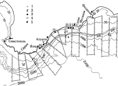
Rice. 2.1. Circulation diagram of the Black Sea waters. 1 - Annular cyclonic flow (CCT) - middle position of the rod; 2 - meanders of CCT; 3 - coastal anticyclonic eddies (surfactants); 4 - cyclonic eddies (CV); 5 - Batumi anticyclonic eddy; 6 - Kaliarskiy surfactant; 7 - Sevastopol surfactant; 8 - Kerch surfactant; 9 - quasi-stationary cyclonic gyres (Kosyan R.D. et al. 2003).
General circulation of the Black Sea waters - the Black Sea Main Current (Rim Current) is characterized by cyclonic water movement (Fig. 2.1). Its main structural element is the Ring Cyclonic Current (CCC). At the Caucasian coast, the KCT occupies a strip along the coast with a width of 50-60 km and carries its waters in the general direction to the north-west. The centerline of the stream is traced at a distance of 20-35 km from the coast, where the velocities reach 60-80 cm / s. This current penetrates to a depth of 150-200 m in summer period, 250-300 m in winter period, sometimes to a depth of 350-400 m. The streamline experiences wave-like oscillations, deviates now to the right, then to the left of its middle position, that is, it inkjet the current meanders. In fig. 2.1. the most common idea of the structure of the currents of the Black Sea is presented.
The results of current measurements carried out for 5 months in the coastal waters in the northeastern part of the Black Sea are shown in Fig. 2.2.
In the figures, we see that the currents cover the entire water column, the changes are synchronous at all horizons.

Rice. 2.2. Fragment of the time sequence of half-hour flow vectors from 20 to 23 December 1997. Point 1 - horizons 5, 26 and 48 m; point 2 - horizons 5 and 26 m; point 3 - horizon 10 m. (Kosyan R.D. et al. 2003).
In these studies, no filtering was performed in order to identify long-period wave currents. The measurements lasted 5 months, i.e. it is possible to show about 5 periods of variability of long-period wave currents and their variability at different points, the difference and common features as you move away from the coast. Instead, the authors provide explanations that are consistent with traditional beliefs.
Rice. 2.3. Location of instruments at the southern coast of the Crimean peninsula at points 1–5 (Ivanov V. A., Yankovsky A. E. 1993).
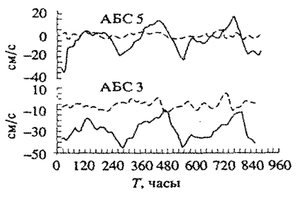
Rice. 2.4. Variability of the speed of currents at measurement points 3 and 5 (Fig. 2.12) at a horizon of 50 m. High-frequency oscillations with a period of 18 hours. And less filtered with a Gaussian filter. (Ivanov V.A., Yankovsky A.E. 1993).
Measurements of currents in the coastal zone using autonomous buoy stations (ABS) were carried out off the southern coast of the Crimean peninsula in the Black Sea at 6 points on 4 horizons from June to September 1991 (Fig. 2.3). (Ivanov V.A., Yankovsky A.E. 1993).
One of the main tasks is to study the waves trapped by the coast. Long-wave currents with a period of 250-300 h were recorded. and an amplitude of up to 40 cm / s. (Fig. 2.4). The phase propagated westward at a speed of 2 m / s. (Note that the value of the phase velocity was obtained from the calculation, and not from the difference in the travel time of the wave at two adjacent points).
Water circulation in the upper layer of the Black Sea is shown according to drifter data (Zhurbas V.M. et al. 2004). More than 61 drifters were launched in the Black Sea and carried by large-scale circulation along the coast.
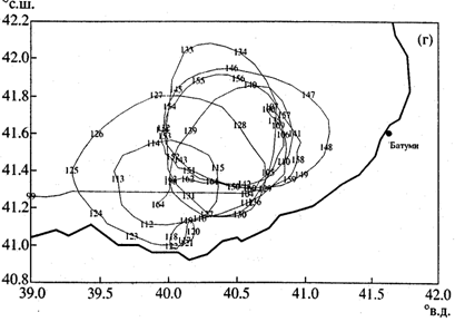
Rice. 2.5. Drifter trajectory No. 16331 in the southwestern part of the Black Sea. The numbers on the trajectory are days that have passed since the start of the drifter (Zhurbas VM et al. 2004).
The regularities of the drifters' advance show the regularities of the currents. The most common misconception about the nature of currents in the Black Sea: cyclonic circulation currents are inkjet meandering current. The meanders, breaking away from the main jet, form vortices. The authors demonstrate such a "vortex" in Fig. 2.5.
The next figure (2.6) shows the variability of the components of the speed of movement (flow) of the drifter along the trajectory. Periodic variability of the current velocity is clearly visible. The period of variability is from 2 to 2 to 7 days. The speed varies from - 40 cm / s. up to 50 cm / s., but the average value of the speed (bold line) is close to zero. The drifter moves along a circular path. It reflects the movement of a water mass of a wave nature.
Bondarenko A.L. (2010) shows the path of one of the drifters in the Black Sea (Fig. 2.7), and the variability of the speed of the drifter along the trajectory (Fig. 2.8). As well as in previous work it can be seen that currents of a wave nature are observed, and not a jet, meandering flow. The path traversed by the drifter in the initial period of his voyage attracts attention. The starting point (0) is in the center of the western part of the sea.

Rice. 2.6. Time series of drifter speed components 16331. Ut-longitudinal component of speed (+/- respectively east / west), Vt- latitudinal component [Zhurbas VM et al. 2004].
According to the views (Fig. 2.1), this point is outside the CCT. But we see that the drifter made a cyclonic path along a stretched almost ellipse, then moved southwest for 20 days. the direction where I got to the CCT and moved in it all the further way. On this trajectory it is possible to calculate the flow velocity in different parts of the trajectory, and according to (Fig. 2.8), the frequency of the high frequency can be seen. and n.h. the variability of this speed.
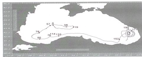
Rice. 2.7. Drifter's path in the Black Sea ( Bondarenko A.L., 2010).
The examples of measurements considered above show that the Main Black Sea Current, the Ring Cyclonic Current (CCT) is the resultant movement of long-period wave currents. The understanding of the geostrophic nature of the CCT currents and its meandering is erroneous. The period of variability of wave currents in the northern part is 260 hours. As you move along the coast, due to the roughness of the coastline and the bottom surface, the components of the current velocity across the coast become commensurate with the components along the coast, the trajectories of drifters acquire an annular shape. The period of variability is greatly reduced.
Rice. 2.8. AND The variability of the speed of movement of the drifter along the trajectory shown in Fig. 2.7.(Bondarenko A. L., 2010).
As a rule, we are very surprised at the seemingly completely ridiculous death in the water of people who can swim and feel confident at depth. Often, alcohol intoxication is considered the cause of such inexplicable accidents, but in fact, life is taken by a phenomenon that, alas, only a few people know about - a rip current.
We will tell you about what it is and how to be saved if you are unlucky enough to find yourself in such an ill-fated place.
So, rip current is a very, very dangerous thing that can destroy even professional swimmers.
Attempts to get away from the current do not lead to anything, and the person is simply seized by a panic state.
The most dangerous is considered to be the rip currents of shallow seas with gentle shores, since sand spits do not allow water to return to the sea during low tide. The water pressure in the strait connecting the estuary and the sea increases, which forms a rapid, and a kind of river appears in the middle of the sea with a current speed of up to 2.5-3.0 m / s.

This is how it looks when the current flows back towards the sea, perpendicular to the coast.
This often happens near the beach during high tides, after which the waves return at different speeds, forming a reverse current.
This is how it might look:

The seething water is not visible here, but the current itself is noticeable and, alas, the people who got into it:


As a rule, the rift current corridor is narrow: 2-3 meters with a current speed of 4-5 km / h. This kind of rip is not dangerous. But if its width reaches 50 m, and its length is 200-400 meters with a current speed of 15 km / h, this phenomenon becomes deadly!


The signs of a rebound flow are:
- section of bubbling water perpendicular to the shore
- area near the coast with a changed water color
- foam, algae and bubbles that move steadily from the coast to the open sea
- discontinuities in continuous wave bands
But it should be remembered that 80% of dangerous rip currents are usually invisible!
As a rule, rips occur near the coast and can carry away a person standing in the water up to their waist into the sea, so you should not go into the water alone, especially if you are not very good at swimming.

Rules of conduct in the rip current

- Do not panic! Calm down and rely on your common sense. Remember that with knowledge of these rules in 100 cases out of 100 you will be able to get out of the tide!
- Save your energy! Do not resist the current and do not swim to the shore - it is useless. Begin to swim calmly to the side, parallel to the shore. If the rip is narrow, you will come out of it very soon.
- If the rip is wide (from 20 meters or more) ... If it becomes clear that the rip is wide enough, you should relax on the water and do not panic. Remember that the reverse flow cannot be long, which means that after 5 minutes it will stop, after which you can swim in the direction of 50-100 meters and head towards the shore. Do not swim to the shore, as soon as you feel that the current has stopped, it may reappear!
Remember the following!

- Bump leakit never pulls to the bottom. This is not a whirlpool. It moves from the coast along the surface, and not in depth.
- The rip current corridors are not wide. Often their width does not exceed 50 meters, and even more often - 10-20 m. That is, you can get out of the rip by swimming 20-30 meters along the coast.
- The length of the rebound flow is limited. It weakens quickly and ends where the waves peak and break. Surfers call this "line up" and this is where they usually try to catch the wave. It is located no further than 100 meters from the coast.
This information can save the lives of your loved ones. Share this post with them!