The Yenisei River and its tributaries. Springs, holy mineral springs, thermal baths of Russia
The Yenisei River is incredibly rich in water. In just one year, it carries about 600 km 3 of water into the Kara Sea. The flow of the Volga carries out three times less, not to mention the other rivers of the European part of our homeland. The length of the Yenisei River is 4287 kilometers. 2,580,000 square kilometers is the area of the basin. Either quiet and leisurely, or stormy and fast-moving, the Yenisei. The flow of the river is constantly changing.
Why is it named like that?
In the Evenki language, the Yenisei sounds like “Ionessi”, which translates as “big water”. For the Khakass, this river is called Kim, and the Tuvans call it Ulug-Khem (Great River). The Kets call the Yenisei Khuk. And for Siberians this is Father Yenisei. The river on the map crosses the entire country from south to north.
Where does it flow from and where?
The source of the Yenisei River is Lake Kara-Balyk, which lies in the Sayan Mountains at an altitude of 3000 m. Biy-Khem (Big Yenisei) originates in this place. This is a very rapids river, with rifts and rapids up to the Tuva Basin. The city of Kyzyl, located in an intermountain depression, is the junction of two rivers - Ka-Khem (Small Yenisei) and Biy-Khem. This is how the Yenisei River is formed. The Upper Yenisei, or Ulug-Khem, is the first 188 kilometers of the entire river.
Having reached the Tuva Basin, the Yenisei is divided into branches, and the riverbed is replete with numerous rapids. At this point the river can reach 650 meters in width and depth - almost 12 meters.

The source of the Yenisei River directs the entire mass of water almost strictly along the meridian from south to north. And its pool has three completely different parts. The upper reaches of the river are surrounded by mountains, and the middle and lower reaches of the riverbed are a kind of border between low-lying Western Siberia and the Central Siberian Plateau.
Passing the hydroelectric station
The city of Shagonara serves as the beginning of the Sayano-Shushenskoye reservoir, which was formed by the giant dam of the Sayano-Shushenskoye hydroelectric power station. After this, the direction of the Yenisei River changes. Here the water turns north. There are 3000 kilometers ahead through the Western Sayan mountains.
Passing a narrow mountain gorge, the Yenisei flows into the Minusinsk Basin. And the river spills over 1000 meters wide.

After the hydroelectric power station there is the Mainskoye Reservoir, which is smaller in size. After this, the Krasnoyarsk Reservoir, which is more than 360 kilometers long, begins across the Abakan River. It is not far from Divnogorsk. Here the Yenisei River can reach a width of almost a kilometer.
After 230 km, below Krasnoyarsk, there is the Kazachinsky threshold. Here the width of the Yenisei is halved, the river crosses rocky outcrops. Water falls from a height of 3.8 meters. The current has an average speed of 20 km/h. The threshold has two rapids. These are shallow areas. Not all ships can navigate here on their own. That's why they are being dragged by the Yenisei ship. Only motor boats and hydrofoils can overcome this section without the help of others.
Angara
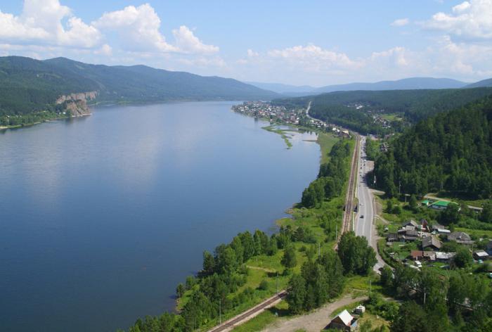
The mountainous character of the river disappears between the mouth of the Angara and the city of Krasnoyarsk. The river valley begins to expand, the current becomes slower, but there are still rapids and riffles along the way. The Angara flowing into the Yenisei changes its character. The right bank is still mountainous, while the left bank is getting lower and becoming floodplain. This is also why the Yenisei is amazing. The mouth of the river starts from the mouth of the Kureyka River.

Before this, wide valleys lie along the river’s path:
- mouth Lower Tunguska- about 40 km;
- Ust-Port and Dudinka - 150 km.
The riverbed in these places is very wide - 2.5 - 5 kilometers. The depth reaches at least five meters.
After connecting with the Angara, Big Pit, a right tributary, joins the Yenisei. Once upon a time, people used this river to reach gold mines.
Then the river takes in the small river Kas. Almost 200 years ago, a canal was dug in its upper reaches, which connected Kas and Ket (the right tributary of the Ob). Using this canal you can sail from the Yenisei to the Ob. Now this canal is not in demand, since the Trans-Siberian Railway exists.
The city of Dudinka is the place after which the Yenisei River breaks into branches. As a result, many islands are formed (Brekhov Islands). The depth of the river can now reach 20-25 meters. Tundra rules the shores. Now the Yenisei is heading towards the Arctic Ocean.
Estuary
The Yenisei has one channel, which in its “throat” forms the Yenisei Bay of the Kara Sea.
The village of Ust-Port is the delta of the Yenisei River, the mouth of the river. The total width reaches almost 50 kilometers. The riverbed is divided into many channels. As a result, the main sleeves are formed:
- Big Yenisei.
- Okhotsk Yenisei.
- Small Yenisei.
- Stone Yenisei.
The speed of the current drops in the delta and lip, decreasing to a minimum. In addition, strong surge winds have such an effect that the current can eventually take the opposite direction.
Tributaries of the Yenisei
The right tributaries of the river exceed the left tributaries in terms of drainage and the amount of water they bring. Lower Tunguska and Angara are the largest of them.

The main left tributaries include: Abakan, Khemchik, Kas, Kantegir, Kem, Elogui, Sym, Dubches, Bolshaya Kheta, Turukhan, Tanama, Malaya Kheta. Right main tributaries: Us, Kebezh, Syda, Tuba, Mana, Sisim, Kan, Bolshoi Pit, Angara, Lower Tunguska, Kureyka, Bakhta, Khantaika, Podkamennaya Tunguska, Dudinka.
Shipping
The Yenisei is the most important waterway Krasnoyarsk Territory. As for the navigable part, the length of the Yenisei River is 3013 kilometers. The cargo flow goes to Dudinka from Krasnoyarsk. And sea vessels make their way to Igarka.
The only ship lift in Russia is located at the Krasnoyarsk hydroelectric power station. Its construction was dictated by the need to continue navigation along the Yenisei. It was stopped due to the appearance of the Krasnoyarsk hydroelectric power station dam. Therefore, this ship lift was built in 1976. And in 1982 it was launched, and it continues to function.

The vessel is loaded onto a platform that stands on rail tracks (gauge 9 meters) and has gearing. Electric traction carries out the movement.
Abakan, Strelka, Krasnoyarsk, Maklakovo, Yeniseisk, Igarka, Ust-Port, Turukhansk are the main piers and ports of the Yenisei River.
Power supplies
48% of the river is fed by snow, rain makes up 36%, underground - 16%. The lower reaches of the river freeze in early October. The Yenisei is known for the massive formation of inland ice. Freezing occurs gradually: the upper reaches - late October-early November, near Krasnoyarsk - mid-November, the mountainous part - December. Freeze-up lasts 150-170 days. The flood on the Yenisei is long and begins in late April-early May. The lower part of the Yenisei - mid-May - early June.
Ecological problems
After the construction of the Sayano-Shushenskaya and Krasnoyarsk hydroelectric power stations, serious environmental consequences arose. Near Krasnoyarsk, Sayanogorsk and Divnogorsk, the Yenisei stopped freezing. For example, near Krasnoyarsk there is almost always an ice-free polynya, which can reach a length of 500 km.
A large area of valuable land was also flooded. Water destroyed archaeological sites, biocenoses, and fish resources. In addition, a significant number of the population were forced to relocate.
Flora and fauna
The main food resources are plankton, nekton and benthos. The latter is the most significant along the entire length of the river. Zooplankton is the least noticeable, since it cannot develop due to the high flow speed, as well as increased turbidity. For this reason, plankton appears in the bay and delta of the river, since the current is weaker here. Muksuns, peleds, omuls and vendace feed on plankton. It develops best from mid-July to mid-September. Graylings, tuguns, and dace mainly feed on aerial food - insects that fly over the water and fall into it.
The main channel of the river does not contain higher aquatic vegetation. It is found in Kuryas, side tributaries, oxbow lakes, deltas and bays. Higher aquatic vegetation is absent in the upper and partially middle reaches due to the fact that the hydrological regime of the river is quite unique. In these places, rocky and pebble soil predominates, low temperatures and strong current. The lower reaches of the river have silty soil and a calmer flow. That's what it is favorable conditions where algae can grow. But their growth is limited short period growing season and significant freezing coastal zone. Pondweeds (14 species) occupy a leading role among 23 species of submerged and semi-submerged plants. In the upper and middle reaches there are mainly fouling algae.

The Yenisei River, home today to 46 species and subspecies of fish, attracts fishermen. In addition, one species of fish-like fish is found here. The river is mainly dominated by marine and brackish water fish:
- arctic char;
- Atlantic herring;
- lycodes polar;
- liparis black-bellied;
- European liparis;
- careproctus;
- slingshot;
- Arctic flounder;
- lumpfish;
- Pacific lamprey;
- Arctic cod or arctic cod;
- navaga;
- Arctic helmeted goby.
Polar cod is of commercial importance. Other species are becoming less and less common.
Also in the Yenisei you can find semi-anadromous fish: salmon, sturgeon, omul, Siberian vendace, muksun, Asian smelt. The river mouth contains redfish, grayling, whitefish, pike and burbot. Fishing becomes unforgettable with such a rich ichthyofauna.
If we compare the rivers of Russia, the Yenisei is in second place in terms of basin area after the Ob. In terms of length, it ranks fifth in the world after the Amazon, Nile, Yangtze and Mississippi. The countdown starts from the Ider River, which flows in Mongolia. The beginning of the river lies in the Khangai Mountains. The length of the river is 452 kilometers. Ider merges with Delger-Muren. And then the Selenga River appears, with a length of 1024 kilometers. It, in turn, flows into Baikal, from which the Angara (1779 kilometers) originates. The latter flows above Yeniseisk into the Yenisei. The river on the map is ultimately 5539 kilometers long. That is why Yenisei occupies fifth place.

The Yenisei is asymmetrical - the right bank is 5.6 times higher than the left.
The city of Kyzyl is the place where the Small and Big Yenisei merge. It is the geographical center of Asia.
One day a whale wandered into the Yenisei. He walked 400 kilometers.
Yenisei - amazing river: camels live in the upper reaches, and polar bears and reindeer can be found in the lower reaches.
The river passes through all climatic zones of Siberia, dividing it into Western and Eastern parts.
The Yenisei River is considered the deepest in the Russian Federation: at the confluence of the Angara, the depth reaches 9 m in the fairway, in the bay - up to 49 m. The maximum depth was recorded at the Osinovsky rapids in the pits - 66 meters. In the river delta - up to 65-70 meters.
Khantayskoye Lake is the largest in the Yenisei basin. The area is 822 sq. kilometer The river basin has more than 184,000 lakes, the total area of which is 32,438 square meters. kilometers. There are more than 20,000 rivers in the basin. Their total length is 337 thousand kilometers.
In literature, the Yenisei is often presented as something mysterious, mysterious and immense. In addition, people were sent here for katroga and into exile.
Yenisei is one of greatest rivers Earth and the most abundant river in Russia. The length of the Yenisei is 3,487 km. The river officially ranks fifth in length in the world - only the Amazon, Nile, Yangtze and Mississippi have surpassed the Yenisei. In terms of basin area (2,580 thousand sq. km), the Yenisei ranks second among the rivers of Russia (after the Ob) and seventh among the rivers of the world. The Yenisei proper begins in the city of Kyzyl at the confluence of the Big Yenisei and the Small Yenisei. He is natural boundary between Western and Eastern Siberia. The left bank of the Yenisei ends with a great West Siberian Plain, and the right bank represents the kingdom of mountain taiga. From Sayan to Northern Arctic Ocean The Yenisei passes through all climatic zones of Siberia. Camels live in its upper reaches, and polar bears live in its lower reaches. The name of the river comes from the Evenk “ionessi” - “big water”. The Khakass call it Kim, the Tuvans call it Ulug-Khem (“great river”), and the Kets call it Khuk. Siberians often call the river “Yenisei-father”.
For the first 188 km, the Yenisei flows under the name Upper Yenisei (Ulug-Khem). The Sayano-Shushenskoye reservoir, formed by the dam of the Sayano-Shushenskoye hydroelectric power station, begins from Shagonar. Having accepted the Khemchik River on the left, the Yenisei turns north and for 290 km breaks through the Western Sayan Mountains and the Minusinsk Basin. After crossing the Sayano-Shushenskaya hydroelectric power station, the small Mainskoye reservoir begins, ending with the Mainskaya hydroelectric power station.
After the confluence of the left tributary of the Abakan River, the Krasnoyarsk reservoir, 360 km long, begins, formed by the dam of the Krasnoyarsk hydroelectric power station near the city of Divnogorsk, at the point where the Yenisei crosses the spurs of the Eastern Sayan. Between Krasnoyarsk and the mouth of the Angara, the Yenisei valley expands again, the river loses its mountainous character, but there are still underwater ridges in the riverbed - a continuation of the spurs of the Yenisei Ridge.
Below the confluence of the Angara, the character of the valley and bed of the Yenisei changes dramatically. The right bank remains mountainous, the left bank becomes low and floodplain. The mouth of the Yenisei begins from the mouth of the Kureyka River. Below the village of Ust-Port the Yenisei delta itself begins. The Brekhov Islands divide the channel of the Yenisei into many channels, of which four main branches stand out: the Okhotsk Yenisei, the Kamenny Yenisei, the Big Yenisei and the Small Yenisei. The total width of the channel at this point is 50 km. Below, the Yenisei flows in one channel, forming the Yenisei Bay of the Kara Sea in the “throat”.
Flowing almost strictly along the meridian from south to north, the Yenisei divides the territory of Russia into approximately two equal parts. The Yenisei basin consists of three completely different parts. In the upper reaches the river is surrounded on all sides by mountains, and in the middle and lower reaches the river bed serves as the border between the lowland Western Siberia and the Central Siberian Plateau.
The Yenisei belongs to the type of rivers of mixed feeding with a predominance of snow. Freezing of the Yenisei begins in the lower reaches at the beginning  October. The Yenisei is characterized by intensive formation of inland ice and autumn ice drift. Freeze-up in the lower reaches occurs from the end of October, in mid-November - in the middle reaches and near Krasnoyarsk, and in late November - December in the mountainous part. In some areas, thick ice deposits appear in the riverbed. The flood on the Yenisei begins in May, sometimes in April, on the middle Yenisei somewhat earlier than on the upper Yenisei, on the lower Yenisei in mid-May - early June. Spring ice drift is accompanied by congestion. The list of the most significant tributaries of the Yenisei includes the following rivers: on the left - Khemchik, Kantegir, Abakan, Kem, Kas, Sym, Dubches, Eloguy, Turukhan, Malaya Kheta, Bolshaya Kheta, Tanama, Gryaznukha; on the right - Us, Kebezh, Tuba, Syda, Sisim, Mana, Kan, Angara, Big Pete, Podkamennaya Tunguska, Bakhta, Lower Tunguska, Kureyka, Khantaika, Dudinka. In total, about 500 more or less significant rivers flow into the Yenisei, and their total length is more than 300 thousand kilometers.
The main tributary is the Angara River, but approximately one year out of ten years another major tributary, the Lower Tunguska River, exceeds it in annual flow.
The Yenisei is the most important waterway of the Krasnoyarsk Territory. Great depths allow sea vessels to ascend the Yenisei almost 1,000 km. For over 2,000 km from the mouth, the Yenisei maintains a significant depth, which ranges from 9 m in the fairway (the area where the Angara flows) to 49 m in the bay. Maximum depths recorded in the pits at the Osinovsky rapids - 66 m and in the delta - 65-70 m. Regular navigation is carried out from Sayanogorsk to the mouth over a distance of 3,013 km. The main cargo flows go from Krasnoyarsk to Dudinka. Main ports and marinas: Abakan, Krasnoyarsk, Strelka, Maklakovo, Yeniseisk, Turukhansk, Igarka, Ust-Port. Sea vessels rise to Igarka. A unique ship lift was built to transport ships from the lower tail of the Krasnoyarsk hydroelectric power station to the upper. The Yenisei is also navigable in the Republic of Tyva. In addition, timber rafting is carried out in the north along the Yenisei.
Built on the Yenisei a large number of bridges. These include city and transport bridges in Kyzyl, a pedestrian-road bridge in the village of Cheryomushki and the Bratsky bridge near the village of Zeleny Bor in the Republic of Khakassia, a bridge near the city of Divnogorsk, railway, Communal, Oktyabrsky bridges, bridge 777 and a bridge on the deep bypass of Krasnoyarsk, bypass road of the federal highway M-53 "Baikal" in the Krasnoyarsk Territory. Currently, construction of a bridge across the Yenisei within the city of Krasnoyarsk has begun.


The construction of the Krasnoyarsk and Sayano-Shushenskaya hydroelectric power stations entailed serious environmental consequences. The Yenisei in the area of Krasnoyarsk, Divnogorsk, Sayanogorsk has stopped freezing, in particular, the extended ice-free polynya below Krasnoyarsk can be up to 500 km long. In addition, the cascade of Yenisei hydroelectric power stations flooded large areas of valuable land, led to the destruction of archaeological monuments, biocenoses, fish resources, and forced relocation of a significant number of the population.
Information
- Length: 3487 km
- Pool: 2,580,000 km²
- Water consumption: 19,800 m³/s
- Confluence of rivers: Big Yenisei and Small Yenisei
Source. my.krskstate.ru
Yenisei River - famous water artery in Russia. This is the deepest river in the country; in this regard, even the Mother Volga is not inferior to it ( largest river in the European part of the Russian Federation). This is an important water artery, a link between the south of Siberia and remote areas of the North. The flow is cultural heritage Russia, he was repeatedly praised in his work by poets and writers. Let's get to know the Siberian river Yenisei, its source, features, tributaries and mouth.
Geography
Geographically, the Yenisei is located in Siberia. The total length of the Yenisei River is 4092 km, taking into account two sources (small mountain rivers Biy Khem and Khaa Khem, forming the bed of the Great River). If you do not take them into account, the length of the Yenisei will be 3487 km. In terms of its dimensions, it is included in the list of the seven largest waterways on the planet.
At the beginning of the journey (the first 180 km), the riverbed is replete with numerous rapids and basins. The width of the river in this section ranges from 100 to 600 meters, the depth does not exceed 12 meters. On the way of the riverbed, the Sayano-Shushenskoye reservoir, formed during the construction of the Sayano-Shushenskoye hydroelectric power station, overflows. The river floods, the current calms down.
The traces of human intervention do not end there - the Mainskaya hydroelectric station appears. Bypassing Abakan, the channel enters the Krasnoyarsk reservoir, the largest of the entire Yenisei cascade (360 km in length). There is also a hydroelectric power station of the same name, on which a unique and only structure in the country was erected - a ship lift. The need for construction arose after the construction of a dam, which became an obstacle to navigation in this section of the Yenisei.
The construction of dams and hydroelectric power stations on the Yenisei was the beginning of an environmental disaster. Hundreds of hectares of agricultural land and land suitable for the construction of settlements were flooded. Thousands of people, indigenous inhabitants of the banks of the Yenisei, were forced to look for a new refuge. Architectural and historical monuments remained under water. Due to disturbances in the water regime, fish disappeared in some places.
The Yenisei is famous for its spring ice drift. The riverbed is located in a harsh climate zone and is covered with a large layer of ice in winter. It takes a month, sometimes a month and a half, to completely clear the ice. The spectacle is exciting, but dangerous - huge ice floes cause congestion and make it difficult for ships and water to pass through. During this period, flooding of coastal settlements often occurs.
General information:
- The Yenisei River flows through several climatic zones. Along the river valley there is a noticeable contrast of flora and fauna. In the area of the source there are camels, native desert animals. The indigenous inhabitant of the estuary is polar bear- master of the North.
- The channel is asymmetrical, this is due to the predominance major tributaries On the one side. The right bank is several times higher than the left, 90% is occupied by taiga.
- The total water area is 2,580,000 sq. km.
- The width varies from a few meters at the source to 50 km at the mouth.
- The bed of the Yenisei forms the border between Western and Eastern Siberia. There is a clear contrast in terms of landscape here. On one side of the river, on the left, remains the West Siberian Plain, on the other bank, on the right, the area turns into mountains and the Siberian taiga.
- The pool is distinguished by its rich ichthyofauna. The waters are home to sterlet, sturgeon, and beluga, which are caught on an industrial scale. There are many other types of fish that are in demand among ordinary anglers.
- The water regime is characterized by prolonged floods and frequent floods during summer rains. In winter, the water level drops and the flow slows down. The reason is ice accumulation.
- Ice cover on the Yenisei begins to form in the second half of September in the upper reaches. In the middle reaches - in mid-October. Middle period Freeze-up lasts from November to the second half of June.
- The food is mixed: about 50% snow, 30% rain and the rest is melt water.
On the map
The Yenisei River on the map of Russia crosses it from the southern border to the shores of the Arctic Ocean. If you look closely, it runs almost strictly along the meridian from south to north and divides the country in half. In the upper reaches, the river bends repeatedly, changing direction. But in general the flow heads north. The riverbed is rough and rapids in places, and calms down in others. In the diagram, the river looks like a deep stream, on the banks of which there are settlements. Behind the village of Ust-Port the river delta begins. The Yenisei floods over 50 km. Sea vessels rise from the ocean to the city of Dudinka.
The map of the Yenisei River is found in several versions. Most maps show a “pure flow” coming from Kyzyl. Angara, Selenga, Baikal, which form the water system, are not indicated.
Source
The stream begins in the Eastern Sayan mountain range. The great river is formed at the confluence of the Biy-Khem and Haa-Khem streams (Big and Small Yenisei). Their channels meet near the city of Kyzyl. There is an obelisk here with an inscription indicating the location of the city in the center of Asia. From here the deep-flowing Great Khem heads his way. To be more precise, the source of the Yenisei River is the high-mountain lake Kara-Balyk. The reservoir where the Biy Khem journey begins. The name has Turkic roots, and is literally interpreted as “black fish”. Researchers say that from space, the contours of the lake actually resemble fish.
There is another theory as to where the Great River originates. Not only the main water artery is taken into account, but also all the streams that form the water system of the main stream flowing into the sea or ocean. It turns out that the Yenisei begins its journey to Mongolia (Khangai Mountains). But for the majority it remains a primordially Russian river.
Estuary
The waterway carries water north to the Arctic Ocean. But which sea does the Yenisei River flow into? Here you need to take into account some peculiarities northern seas. Near the coast, they are divided into numerous bays (another name for the lip), deeply cut into the land. The mouth of the Yenisei River is the Yenisei Bay or the Yenisei Bay of the Kara Sea.
Tributaries

In total, about 500 rivers and streams flow into the Yenisei. Their total length exceeds 300,000 km. The main tributaries of the Yenisei River flow in from the right. They contribute to the formation of the basin.
Large tributaries of the Yenisei:
- Angara - main river, feeding the Yenisei. The stream, whose source is Baikal, is the cleanest lake. This is a river whose basin is half the size of the Yenisei, but the width of the channel is not inferior to the main one water flow. There is still debate as to whether it is a tributary of the Yenisei, or vice versa.
- Podkamennaya Tunguska and Lower Tunguska are large tributaries flowing in from the right.
- Kas is considered a small tributary, but is important in terms of navigation. Navigation from the Yenisei to the Ob and back was carried out through an artificial canal. After the construction of the Trans-Siberian Railway, shipping slowed down.
- Kureyka is a right tributary that flows through the Krasnoyarsk Territory. Navigable river. The Kureyskaya hydroelectric power station operates there. Of the natural attractions, tourists are attracted by the Kureysky Waterfall.
- Abakan is a left tributary, located in Khakassia and the Krasnoyarsk Territory. Abakan attracts tourists - there are settlements of Old Believers on the banks, the water is rich in fish, and mushrooms and berries are found in the coastal forests. Due to the proximity of Baikonur, the river and its surroundings are polluted with toxic waste.
- The Big Pit is a right tributary that used to transport workers to the gold mines in past centuries.
Cities
The Yenisei Valley is inhabited, on the banks there are big cities and villages. They are connected to each other by highways and waterways. The banks are connected by numerous road bridges. There are hydroelectric power stations operating in the river basin, meeting the needs of the population, social and industrial facilities.
What large cities are located on the Yenisei River:
- Kyzyl is a city in the Republic of Tyva. It is located right at the confluence of the Big Yenisei and the Small. Due to the sharply continental climate, the city is equated with the regions Far North. From a geographical point of view, it is the center of Asia.
- Abakan is the capital of Khakassia with a population of 181,000 people. A relatively young settlement (80 years since its founding).
- Sayanogorsk is a city in the Republic of Khakassia. Industrial centre. According to one version, the construction of Sayanogorsk began by order of Peter the Great. According to another version, there was a working settlement here for the builders of the Sayano-Shushenskaya hydroelectric power station, which a few years later turned into a large city.
- Divnogorsk - the city received its name because of its surroundings by high cliffs. Divnogorsk stands on the Yenisei, but Mana and Biryusa also flow through it. The Krasnoyarsk Reservoir enters the territory of the settlement.
- Krasnoyarsk is the industrial and economic center of Siberia, the administrative capital of the Krasnoyarsk Territory. Ancient city, which has numerous architectural and historical monuments: ancient houses, churches, monasteries, museums. Krasnoyarsk stands on both banks of the Yenisei. Due to the abundance of metallurgical and industrial enterprises, an unfavorable environmental situation has developed in the city.
- Yeniseisk is located on the left bank of the Great River, surrounded by taiga and swamps. One of the oldest settlements in Siberia.
- Turukhansk is the oldest Siberian city, one of the first Russian settlements in the vastness of Siberia, now a river port. With the advent of Soviet power, Turukhansk and its surroundings turned into places of exile for political prisoners.
- Igarka is a town with a population of just over 4,000 people. Currently it includes two residential neighborhoods. Performs a role major port, accepts sea and river vessels. Most of the vessels are barges with oil and passenger ships that deliver shift workers to and from drilling platforms.
- Dudinka is a regional center on the Taimyr Peninsula with a population of 21,000 people. The city is located beyond the Arctic Circle, which is why it has a harsh climate with long winters and short, cool summers. IN winter time The polar night lasts for 45 days, during which it gets light for 2 hours. IN summer period A series of polar days sets in - the sun does not set below the horizon. Dudinka is one of the few closed cities for foreigners. To visit, permission from the Russian authorities is required.
In culture
Since ancient times, the Great River in Siberia has aroused respect among the peoples inhabiting its banks. The Evenks composed legends and epics about the water artery, the Tuvans saw the confluence of the Big Yenisei with the Small Yenisei as a special sign from above. When the first Russians began to explore Siberia, they called the Yenisei stream Father. New residents preferred to settle on the shores. And not in vain, because this waterway was the source of life for the then indigenous population. Fish walked in its waters, cargo and passenger ships plied along it.
The river was repeatedly glorified in Astafiev’s works. The author is a native resident of that region. He spent his childhood and youth there; after the war, he again chose to return to the village, where he lived until old age. Astafiev was an expert Siberian culture and folklore. In his books, the reader can feel the true Spirit of Siberia and the kindness of the people there. A.P. mentions the Yenisei in his works. Chekhov. While traveling to Far East The writer, during a stop in Krasnoyarsk, saw the Great River and could not remain indifferent.
The Yenisei is one of the greatest rivers not only in Russia, but throughout the world. The geographical location of the water area is the territory of Siberia. The Yenisei stretches from the Arctic Ocean itself for thousands of kilometers all the way to. It is noteworthy that the name comes from the word “Ionessi”, which is translated from the Evenki dialect as “ great water" In turn, the Big Yenisei was named Biy-Khem, and the Small Yenisei - Kaa-Khem.
Description of the water area
The mouth of the Yenisei River originates from a lake called Kara-Balyk, which is located in the highlands in Eastern Sayan Mountains. This place is considered the source of Biy-Khem. As for the Kaa-Khem, it has several tributaries in Mongolia. The confluence of the mouths occurs off the coast of the city of Kyzyl.

The largest reservoir on the Hem route is Krasnoyarsk. Its length is about 360 km. Moreover, the width of the valley in some places exceeds 5 km. As for the riverbed, it is about 500 meters long. Closer to the mouth of the Lower Tunguska, the basin expands significantly - up to 40 km, and at Ust-Port - up to 150 km. At the same time, the channel retains its dimensions ranging from 2500 to 5000 m. The depths of the river range from 5 to 30 m. The last obstacle before the sea is the Brekhov Islands, which divide the channel into many channels. The total width of the strait is 50 km. The final point of the route is the Kara Sea. It connects to the sleeve
Features of the water area
The direction of the Yenisei River is linear: from south to strictly north. The Khem water area is classified as a mixed feeding type. This indicator is determined by the types of sources. A large share of the basin's nutrition is snow, it is 48%. Next come rain inflows - 36% and underground - 16%. The nutrition indicator means the source of filling the water area with water. The flow of the river, in turn, depends on them.
The Yenisei begins to freeze in early October. A strong ice drift forms in the lower reaches of the basin, which lasts until the end of November. In mountainous areas, large ice dams often occur. In spring comes the time for floods, sometimes emergency ones. In the upper reaches of the water area there is often significant flooding of coastal villages, lasting until mid-summer.
The lowest water consumption is observed at the source of the river - 1009 cubic meters. m/s, the largest is near Igarka (more than 18,000 cubic m/s). In terms of runoff, Khem ranks first in the country. The annual volume varies within 630 cubic meters.
Tributaries and mergers
The mouth of the Yenisei River is homogeneous, but the further channel is constantly connected with other large basins. The most significant and large tributaries of the Hem are the Abakan, Sym, Kantegir, Elogui, Kheta, Dubches, Tanama, Tuba, Sisim, Tunguska, Us, Bakhta, Kureyka, Angara, Dudinka, Kebezh, Khaitaika and others. In total, more than 500 rivers, whose total length is about 300 thousand km, will flow into the water area.
In terms of area, the right tributaries significantly dominate over the left ones. The main flowing river here is the Angara. Nevertheless, once every 10-12 years the Lower Tunguska is ahead of it in terms of annual drainage. The reason for this hydrological activity is underground flow and snow melting. It is interesting that after the point of confluence with the Angara, the modern Yenisei is considered precisely the Angara. It's all about superiority in indicators such as collection area and water consumption. However, Russian scientists call this area the Yenisei-Angara. The river flows at a right angle.
Big Yenisei
This water area occupies a special place in the hydrological system of Russia. The length of the river is more than 605 km with a total basin area of 56.8 thousand square meters. km. The average water consumption fluctuates around 585 cubic meters. m/s. This characteristic of the Yenisei River determines the level of the total flow of the Khem water area.

The source is considered to be a lake called Kara-Balyk. Its height above sea level is 1521 m. The river is considered an administrative part of the Republic of Tuva. The shipping route stretches 285 km from the very mouth. It should be noted the high water content of this part of the water area. It is explained by the large area and depth of the Todzha Basin. Its relief allows the formation of a huge drainage basin. About a dozen large tributaries flow into Biy-Khem, the largest of which are Systyg, Toora and Khamsara.
The rockiest part of the coast is located on the border with Buryatia and Irkutsk. There is also a unique geological characteristic of the river here. The Yenisei flows through the vents of nine inactive volcanoes. Thanks to such a dangerous terrain, this area still remains untouched by industrial passages. Today this basin is represented by Lake Azas, which is considered a nature reserve and attracts tourists from all over the world.
Shipping history
Currently, the Yenisei is the most important transport and industrial artery of Russia. Dozens of large and small ships ply along the river every day. Nevertheless, due to the complex terrain and sharp channel, disasters often occur in the water area.

Back in 1877, the Thames steamship and a schooner called " Northern lights" Only a few of both crews managed to survive. Between 1892 and 1941, about a hundred ships sank as a result of heavy ice drift.
IN last years The Yenisei is dangerous primarily with its endless floods. As a result, many ships are holed in the mountainous areas of the basin.
Environmental tragedy
Today, the largest accidents at hydroelectric power stations are associated with the Yenisei River. In 2009, as a result of the Shushenskoye basin spill, chemical substances and harmful oils. Several halls and important sections of the station were also destroyed. The tragedy resulted in the loss of dozens of lives of hydroelectric power plant workers.
The cause of the disaster was named old technology, which was in disrepair. The 2009 water spill was a huge human and environmental tragedy for the entire country. Only a year later it was possible to partially eliminate the damage from the accident, estimated at almost 22 billion rubles.

In 2014, the state allocated a similar amount for the modernization of the Sayano-Shushenskaya hydroelectric power station in order to prevent a repeat tragedy.
Good position
The river passes through such settlements as Sayanogorsk, Kyzyl, Novoselovo, Zheleznogorsk, Cheryomushki, Turukhansk, Divnogorsk, Ust-Port, Minusinsk, Karaus and others. There are dozens of large bridges between the cities. The newest of them is the bypass road leading to the M53 highway.
Almost all settlements in the Yenisei water area have direct access to the sea. This makes it easier to transport large loads. There are 3 hydroelectric power stations operating on the river drainage, providing electricity to entire regions.
The water flow along the length of the river increases unevenly, which is associated with large tributaries - the Abakan, Angara, Podkamennaya and Nizhnyaya Tunguska. The average long-term water flow of the Yenisei near the city of Igarka is 18,500 m 3 /s, which corresponds to a runoff volume of 584 km 3 /year. Towards the mouth, due to the confluence of large tributaries, the river’s water flow increases to 625 km 3 /year.
The Yenisei is divided into three parts: the Upper Yenisei - from the merger of its components in the city of Kyzyl to the exit from the Western Sayan near the city of Krasnoyarsk; Middle Yenisei - from Krasnoyarsk to the mouth of the river. Chickens; Lower Yenisei - from the mouth of the river. Kureyki to the Yenisei Bay.
The river is fed by snow (about 50%) and rain (36–38%) with less significant groundwater. According to the water regime in the upper reaches, the Yenisei belongs to the Altai type, with floods extended until autumn due to melting snow at various altitudes in the mountains, and downstream - to the East Siberian type, with high spring floods, summer-autumn low water and flood periods. Winter low water (November–April) is characterized by low flow. On the Lower Yenisei, the flood begins in May and ends at the end of July. The share of melt water runoff at this time is 83%. Maximum water flows are observed at the end of May - mid-June during ice drift or in the first days after the river is cleared of ice. Near Igarka, the highest water flow was recorded on June 12, 1969 (176,000 m 3 /s); The average long-term maximum water flow here is 132,000 m 3 /s.
The hydrological regime of the Yenisei is significantly influenced by large reservoirs on the Yenisei and its tributaries - the Angara, Khantaika and Kureyka, regulating from 23% to 36.7% of the annual water flow. The Sayano-Shushenskoye Reservoir (filled in 1985) carries out seasonal flow regulation. The Mainskoe reservoir is a counter-regulator of the Sayano-Shushenskaya hydroelectric power station, smoothing out level fluctuations that occur when changing its operating modes. The Krasnoyarsk reservoir (filled in 1970) carries out long-term flow regulation. With the commissioning of the Boguchansky hydroelectric complex (see Boguchansky Reservoir) in the lower reaches of the Angara, the degree of regulation of the Yenisei flow increased to 38.6%. The development of hydropower resources did not affect the annual flow of the Yenisei near Igarka. The intra-annual regime of water flow, the flow of suspended sediment and heat, and the ice regime have undergone noticeable changes; in the downstream of the Krasnoyarsk hydroelectric power station, water mineralization has increased.
Summer-autumn minimum water flows on the Yenisei occur in August, September or October and average 13,800 m 3 /s. Flow regulation led to a slight decrease in the water content of summer-autumn floods.
The wettest months are May–July. IN natural conditions they accounted for more than 63% of the annual water flow. Runoff share winter months(November–April) was 13.1%. Under conditions of flow regulation, winter runoff increased (up to 21.5% of the year), flood flow decreased (May–July - up to 58.3%). To a lesser extent, the flow is disturbed in spring flood. In July–October, water consumption is 86–98% of household values.
The highest water levels in the upper reaches of the Yenisei depend on the supply of meltwater from the mountainous part of the basin and are observed from April to July. In the middle reaches, the highest levels are established in mid-May, in the lower reaches - until the end of the first ten days of June and are associated with ice jams, which can lead to floods. The range of water level fluctuations in the Sayan Mountains is 7–14 m, near the city of Krasnoyarsk – 10.7 m, near the city of Yeniseisk – 15.6 m, near the city of Turukhansk – 17–20 m, near the city of Dudinki – 11–15 m The height of the rise in levels during floods at the top of the delta is about 8 m, at the sea edge of the delta – 1.3 m.
In the mouth area of the Yenisei, the level regime depends on tidal and surge phenomena. The magnitude of the tide is 60 cm at the mouth, 35 cm at Baikalovo, 10 cm at Dudinka. Surges penetrate a distance of 977 km up the river. Surge winds predominate in summer, and downwind winds predominate in winter. The height of the surge wave is about 1 m. Tides and surges lead to the occurrence reverse currents, which are observed near the city of Dudinka; their speed at the mouth is 0.30 m/s.
Ice formation begins in the lower reaches of the river on average on October 17 and by October 25 it spreads to the upper reaches of the river. The duration of autumn ice drift decreases down the river from 25 to 4–5 days. Freeze-up occurs unevenly, and on some rapids it does not occur at all. In the downstream of the Krasnoyarsk hydroelectric power station, an ice-free polynya with a length of 150 to 300 km remains in winter. Ice dams form in some areas. The ice thickness exceeds 100 cm, in severe winters – 150–170 cm. Spring ice flow is stormy, with powerful jams. Jam level rises are the main cause of floods on the Yenisei. Clearing the river of ice begins in the upper reaches on May 3–10, and in the mouth area on June 11.
Ice formation in the Yenisei mouth area begins on October 9–13. The ice thickness reaches 1.5–1.9 m. Spring ice drift in the delta branches begins on June 19 on average. Recently, it has been practiced to break ice with icebreakers 2–3 weeks earlier than the natural time of breaking.
The average long-term flow of suspended sediment before the creation of reservoirs near Igarka was 12.0 million tons/year; The average water turbidity is 22 g/m3, the highest is 30–90 g/m3. After the construction of hydroelectric complexes, the flow of suspended sediment decreased to 4.7 million tons/year, the average turbidity - to 8 g/m3, the value of the highest turbidity remained almost unchanged. The maximum discharge of suspended sediment under these conditions averages 5210 kg/s; their passage lags behind the peak of the flood by an average of seven days; the highest sediment flow rate is 19,000 kg/s. Floods account for about 90% of sediment runoff. Under conditions of river flow regulation, the value of suspended sediment runoff and water turbidity decreased 10 times in May, 1.3–2.4 times in other months, and increased slightly in January–April. Along the length of the river, changes in the average discharge of suspended sediment (kg/s) for 1956–1966. (numerator) and 1968–1993 (denominator) occurred as follows: Divnogorsk – 200/7.8; Bazaikha – 215/9.6; Yeniseisk – 380/124; the mouth of the Podkamennaya Tunguska – 467/169; Igarka – 391/161.
The Upper Yenisei from the city of Kyzyl to the Sayano-Shushenskoye reservoir has a branched semi-mountain channel, sand and pebble sediments. Below the mouth of the Seiba, the channel is incised and looks like a rocky chute with numerous single stones and rapids (Bolshoi, Dedushkin, Khutinsky). Many rapids are now flooded by reservoirs. The average kilometer drop in the area from the city of Kyzyl to the river. Khemchik 152 cm/km, current speed more than 8 m/s. The channel has the greatest branching in the Khamsary section (“Forty Yeniseev”). In the Minusinsk basin between the Mainsa hydroelectric station and the Krasnoyarsk reservoir, the channel is wide-floodplain, with a system of complex branches and sand and pebble rifts. Above Krasnoyarsk, the Yenisei crosses the spurs of the Eastern Sayan, flowing in a narrow canyon between high rocky banks - a “pipe” 1.2–3 km wide. The Krasnoyarsk hydroelectric complex is equipped with an inclined ship lift.
The middle Yenisei crosses successively the Krasnoyarsk ridge, the Kansk depression and the spurs of the Yenisei ridge (Ataman ridge). This section of the river is under the regulatory influence of the Krasnoyarsk reservoir, which completely intercepts the flow of tractional sediment. A typical section of the Middle Yenisei is a multi-kilometer narrowing of the channel (up to 0.7 km) with almost vertical rocky banks 30–40 m high and up to 35 m deep - “Cheeks”. Between the Atamanovsky narrowing and the mouth of the Angara, rocky capes - “bulls” - jut into the riverbed. The channel is incised, straight, with rifts (Berezovsky, Ermolaevsky, Atamanovsky “stones”) and rapids (Kazachinsky, Osinovsky). Riffles are rocky ledges at the bottom, covered with a layer of sediment up to 2 m thick. The Kazachinsky threshold has a length with rifts of about 4 km, the total drop here is 3.8 m, the width of the channel is 550–600 m instead of the usual 800–1300 m. To overcome the threshold upstream large trains vessels use an auxiliary vessel - a tuyer. Below the Osinovsky threshold, the river passes through a rocky gorge with a channel width of 740 m and depths of up to 60 m. Below the mouth of the river. The width of the Lower Tunguska channel reaches 20 km, dividing into numerous branches with a depth of 14–20 m.
The Lower Yenisei from Kureika to Ust-Port forms incised bends, the width of the channel is 1.5–3.5 km, the depth is from 5 to 35–40 m. The width of the channel at Dudinka and Ust-Port is up to 2.5–5 km. The minimum depths on the Lower Yenisei are from 5 to 8.5 m. Below the confluence of the river. Kureyka is dominated by depths from 14 to 20 m, below Dudinka 20–25 m.
The main delta branches - the Small, Bolshoi, Kamenny and Okhotsk Yenisei - receive a total of 95% of the water flow at the top of the delta, the rest - into the secondary channels. At the main branching point, at a high flow rate (70 thousand m 3 /s), 75% of the water flow is concentrated at the source of the Big Yenisei, 23% flows into the Small Yenisei and 2% into the Okhotsk channel.
Active modern delta-forming processes are confined to the mouths of the Deryabinsk Yenisei and the Bolshoi Yenisei, where the mouth surface spits extend into the bay at 10–30 m/year, and underwater ones – 60–120 m/year. The linear speed of delta protrusion does not exceed 10–30 m/year.
The waters of the Yenisei are low- and medium-mineralized. In the upper reaches, mineralization and total water hardness during the year vary within the range of 31–197 mg/l and 0.41–2.44 mg-eq/l, respectively. The highest values of mineralization and hardness are observed during winter low-water periods: in March 111–197 mg/l and 1.24–2.44 mg-eq/l, respectively; the smallest are confined to the peak of the spring flood - 36–86 mg/l and 41–1.09 mg-eq/l. Throughout the year, water belongs to the hydrocarbonate class and calcium group. Below the mouth of the Angara, the content of chlorine ions increases. Here, the left-bank tributaries carry weakly mineralized waters, while the right-bank tributaries carry waters with high mineralization.
Toward Igarka, water mineralization increases from 20 to 65 mg/l during the spring flood period, to 180–230 mg/l during the winter low water period, but does not exceed 120 mg/l during the summer-autumn period. Closer to the mouth of the Yenisei, the mineralization and hardness of water decreases.
After the construction of the Krasnoyarsk hydroelectric complex, mineralization, hardness and the content of major ions in the water decreased. The relative abundance of major ions did not change. The ion flow of the river near Igarka averages about 70 million tons/year.
The waters of the Yenisei are inhabited by whitefish, salmon and sturgeon fish. The ichthyofauna includes 46 species and subspecies of fish. Semi-anadromous species (sturgeon, nelma, vendace, musk, whitefish, omul and smelt) live in the brackish waters of the Yenisei Bay and rise hundreds of kilometers into the Yenisei to their spawning grounds. The main habitat of whitefishes is the lower reaches of the river. Flow regulation has led to a decrease in fish numbers in the upper and middle reaches. Sturgeon and sterlet stopped rising above 400 km from the Krasnoyarsk hydroelectric power station. Throughout the Yenisei, only pike, taimen and burbot are common.
The annual water intake from the Yenisei averages 3,500 million m 3, when returned Wastewater about 2800 million m 3; Of these, half are either insufficiently purified or not purified at all. This creates a relatively high degree of water pollution, exceeding the MPC for many indicators. An unfavorable radiation situation was noted below Krasnoyarsk.
The main sectors of the economy in the Yenisei basin are water transport, forestry and wood processing industries, mining, metallurgy, and fisheries. Igarka and Dudinka are major seaports. Products of the Norilsk Mining and Metallurgical Plant are exported through Dudinka. Navigation on the Yenisei is carried out to the Main hydroelectric complex, which, like the Sayano-Shushensky one, does not have navigation facilities. This significantly reduces the water transport importance of the Upper Yenisei. Above the Sayano-Shushenskaya hydroelectric power station, the Yenisei is navigable to the city of Kyzyl. Navigation is limited by depths on some rifts (Turushinsky and Lipatnikovsky on the Lower Yenisei) and rapids (Berezovsky, Ermolaevsky and Atamanovsky “stones”, Kazachinsky, Osinovsky rapids). To increase the depth to 10.4 m, dredging is being carried out on the Turushinsky rift in the Yenisei delta. Large-scale dredging and straightening work is being carried out on the rifts from Krasnoyarsk to the village. Atamanovo.
The main ports on the Yenisei: Abakan, Krasnoyarsk, Lesosibirsk, Igarka, Dudinka; piers – Shushenskoye, Minusinsk, Turukhansk, Ust-Port.
V.N. Korotaev, V.V. Ivanov, R.S. Chalov