Features of nature, permafrost of northeastern Siberia. Features of Eastern Siberia
The hydrographic network of the region belongs to the basin of the Arctic Ocean and is distributed over the private basins of the Kara, Laptev, East Siberian and Chukchi seas.
Eastern Siberia covers a vast part of the territory of the Asian continent, located east of the Yenisei and extending to the shores of the Bering Sea, and in meridional direction- from the shores of the Northern Arctic Ocean to the Mongolian People's Republic.
The hydrographic network of the region belongs to the basin of the Arctic Ocean and is distributed over the private basins of the Kara, Laptev, East Siberian and Chukchi Seas. By the nature of the relief, Eastern Siberia belongs to mountainous regions, and here mountains of medium height and vast plateaus predominate, while lowlands occupy only small spaces.
Between the Yenisei and Lena is the Siberian Plateau, dissected by erosion. Its height is on average 300-500 m above sea level; only in places among the plateau stand out higher elevations - the Putorana ridge (1500 m), the Vilyui mountains (1074 m) and the Yenisei ridge (1122 m). In the upper part of the Yenisei basin is the Sayano-Baikal fold country. This is the highest mountain region of the region, with heights up to 3480 m (the peak of Munku-Sardyk).
To the east of the lower reaches of the Lena stretches the Verkhoyansk-Kolyma mountainous country, characterized by sharp contrasts of lowland and mountain landscapes. Along the right bank of the Lena stretches a powerful arc of the Verkhoyansk ridge with heights up to 2000 m, further to the east rises the Chersky ridge - a mountain knot with a height of 2000-3000 m, the Tas-Khayakhtakh ridge, etc. Along with the mountain ranges, the Verkhoyansk-Kolyma mountain region includes Oymyakonskoe, Nerskoe and Yukagir plateaus. In the south, the border of the region is made up of the Yablonovy, Stanovoy and Duzhgdzhur ridges, whose heights reach 2500-3000 m. In the east, along the coast of the Sea of Okhotsk, the Kolyma ridge, or Gydan, stretches.
On the territory of Eastern Siberia, there are also low-lying plains, among which the Lena-Vilyui lowland stands out for its size, which is a grandiose synclinal trough. The extreme north of the region, along the coast of the marginal seas, is occupied by the Subpolar Lowland, the height of which does not exceed 100 m above sea level; lowlands are also located in the lower reaches of the Alazeya, Kolyma and Indigirka.
The subpolar lowland is occupied by tundra and forest tundra. Most of the territory of Eastern Siberia belongs to the taiga zone. The forest landscape is dominated by Daurian larch, which is most adapted to the harsh climate and the presence of permafrost; much less pine here. The forests of Eastern Siberia are slightly swamped.
The taiga zone on the territory of Eastern Siberia is dominant and extends far to the south; sections of the steppe and forest-steppe are interspersed in it in the form of spots (the Minusinsk depression, which has a steppe character, the steppes of Transbaikalia).
Geologically, the area is characterized by a shallow occurrence of bedrock crystalline rocks, which often come to the surface here. Large distribution, especially within the Central Siberian Plateau, are ancient igneous rocks - traps, which form characteristic vertical outcrops in the form of columnar units (locally - pillars) along the river valleys.
The rivers of Eastern Siberia are predominantly in the form of mountain streams; flowing through the lowlands, they acquire a flat character.
The climatic conditions of Eastern Siberia are largely determined by its geographical location within the Asian continent. Great influence on climatic conditions district has an emerging winter time in the center of Asia, the Siberian anticyclone is an area of high pressure, a powerful spur of which occupies the whole of Eastern Siberia. Under the conditions of a stable anticyclonic weather type, winter is characterized by low cloudiness and a predominance of calm, which entails a strong cooling. Clear, severe, little snow, stable and long winter and rather arid, short and hot summer - these are the main features of the climate of Eastern Siberia. Frosts, for example, in the region of Verkhoyansk and Oymyakon reach -60, -70. These are the lowest air temperatures that are observed on the globe, therefore, the region of Verkhoyansk and Oymyakon is called the pole of cold. Average monthly air temperatures of the coldest month - January - fluctuate from -25 -40 in the south of the region to -48 in Verkhoyansk. In summer, daily air temperatures sometimes rise to 30-40. The average monthly temperatures of the warmest month - July - in the northern part of the region (in the tundra zone) are about 10, in the south, in the upper reaches of the Yenisei (Minusinsk depression), up to 20.8. Air temperature transition through 0 to far north observed in mid-June, in autumn - in mid-September, and in the southern parts of the region (Minusinsk depression) - in the twentieth of April and in mid-October. The arid Minusinsk Basin stands out sharply in its climatic conditions; its climate approaches that of the steppes of the European part of the USSR.
There is little rainfall. In the predominant part of the district, their number does not exceed 200-400 mm per year. The Leno-Vilyui lowland (200 mm) is extremely poor in precipitation. Even less precipitation falls in the north, in the Subpolar Lowland, where their annual amount does not exceed 100 mm. So, for example, in the region of the river delta. Lena falls only about 90 mm per year. Approximately the same amount of precipitation falls on the islands of the Arctic zone (New Siberian Islands, Wrangel Island). Precipitation is more abundant in the Sayan Mountains, where its annual amount reaches 600-700 mm, and in some places even 1200 mm.
Most of the precipitation (70-80%) falls in the summer in the form of rains, which are usually of a continuous nature. In the cold part of the soda, there is little precipitation - no more than 50 mm.
The snow cover is notable for its low thickness; only in the Yenisei basin and within the Central Siberian Plateau does a relatively large amount of snow fall. The least amount of snow falls in the Yana and Indigirka basins.
In the harsh climate of Eastern Siberia, with its long, little snowy and cold winter, a characteristic feature of the region is the widespread permafrost. The thickness of the permafrost layer in the northern and central regions reaches 200-500 m and more. In the southern parts of the region (Transbaikalia, the basin of the upper Yenisei), the thickness of permafrost decreases, more or less significant areas devoid of permafrost (taliks) appear.
The presence of permafrost creates complex hydrogeological conditions. Groundwater reserves in most of Eastern Siberia are very poor; groundwater is represented mainly by perched water, which does not feed the rivers. Outcrops of subpermafrost waters are relatively rare and confined to areas of young faults in the earth's crust and karst areas (upper Aldan).
In a number of places (the Leno-Vilyui lowland, the lowlands of the estuarine sections of the pp. Kolyma and Indigirka, etc.) are found at a shallow depth from the surface buried ice occupying large areas; their thickness sometimes reaches 5-10 m and more.
The harsh climate and permafrost determine the uniqueness of the water regime in Eastern Siberia. With the complete impermeability of frozen soils, low filtration and evaporation losses, the surface runoff here is relatively high, despite the small amount precipitation. Permafrost is the reason for the poor supply of rivers with groundwater and the widespread phenomenon of freezing, as well as the formation of icing. In permafrost conditions, erosional processes also develop in a peculiar way. Soils bound by permafrost are difficult to erode, and therefore deep erosion develops poorly. Lateral erosion predominates, leading to the expansion of the valleys.
Research carried out in last years, showed that modern glaciation has a significant distribution on the territory of Eastern Siberia. It is found in the most elevated parts of the Verkhoyansk and Chersky ranges - in the upper reaches of the Yana and Indigirka basins. The area of glaciation reaches 600-700 km2, which is approximately equal to the area of modern Altai glaciation. Glaciers are small. The largest glacier of the Sauntarskaya group (on the watershed of Indigirka and Okhota) is up to 10 km long.
Internet source:
http://www.astronet.ru/db/msg/1192178/content. html
1) Using the atlas map, determine the specifics of the geographical location of Eastern Siberia.
The vast territory of Eastern Siberia, which occupies a fourth of the area of Russia, stretches from the shores of the Arctic Ocean to the border with Mongolia, from the left bank of the Yenisei to the watershed ranges of the Far East. The natural features of Eastern Siberia are determined by its size, its location in middle and high latitudes, the general inclination of the territory towards the low coast of the Arctic Ocean, and its greater distance from the Atlantic Ocean. In addition, the barrier of mountain ranges almost destroys the influence of the Pacific Ocean, which explains the continentality of the climate.
2) Compare this region in terms of area with other regions of Russia, with foreign countries Europe.
Eastern Siberia is the largest natural region in Russia. The area of the listed territories could accommodate several large European states, such as France, Great Britain, Germany, Spain
3) What subjects of the federation are included in this natural region?
Krasnoyarsk region, Republic of Tyva, Republic of Buryatia, Irkutsk region, Trans-Baikal Territory, Yakutia.
Questions in a paragraph
* Using the maps of the atlas, compare the dimensions and heights of the Vitim plateau, Stanovoy and Aldan highlands with the mountain ranges of Europe. What conclusions can be drawn?
The size and height of the European mountain ranges are generally inferior to the size of the highlands of Eastern Siberia. In terms of height, only the Alps can compare with the highlands of Eastern Siberia. The mountains of southern Siberia were formed in the Cenozoic time as a result of the latest tectonic movements, when folded-block mountains formed on the site of the ancient Precambrian and Paleozoic mountains. Tectonic movements continue to this day. This explains great heights uplands and their sizes.
*Tell us about the largest deposits in Eastern Siberia, about the patterns of their placement. What are the difficulties in their development?
Among natural resources Eastern Siberia highest value have mineral, among which the most important are fuel and energy. About 80% of the country's hard and brown coal reserves are concentrated in Eastern Siberia (Tunguska, Lena, Irkutsk-Cheremkhovo, South Yakutsk and other basins). Eastern Siberia is also rich in ore deposits; iron ore Korshunovskoye and Abakanskoye deposits, Angara-Pitek region; copper-nickel ores of Norilsk, the formation of which is associated with trap magmatism, polymetals of Altai, bauxites of the Eastern Sayan Mountains.
known large deposits non-metallic minerals: mica, graphite, Icelandic spar, building materials, salts (for example, salt in Usolye-Sibirsky). Diversity mineral resources due to the complexity of the structure of the earth's crust, as well as geological history territory formation. harsh, harsh continental climate Eastern Siberia, the predominance of strongly dissected relief, permafrost and weak population of the territory hinder its development.
Questions at the end of the paragraph
2. Determine in which time zones Eastern Siberia is located. With which regions of Russia does it have the biggest time difference?
6,7,8 time zones. Biggest difference in time from European part and the Far East.
3. Name the main features of the nature of Eastern Siberia and explain their reasons.
By natural features This is a country with pronounced features of continentality. The continentality of the climate is manifested in a large range of temperatures in winter and summer (it reaches 50°, and in Eastern Yakutia - 100°), as well as in sharp temperature fluctuations during the day and in a relatively small amount of precipitation. main reason the formation of such a climate - a central position, remoteness from the coasts, relief. The relief is characterized by a general significant elevation above sea level. Most of the region is occupied by the Central Siberian Plateau, the average height of which is 500-700 m. It was formed within the most ancient part of the earth's crust - the Siberian platform. The Central Siberian plateau in the north, south and east is bordered by a giant amphitheater of mountain ranges. These mountains are characterized by a complex geological structure and large fluctuations in relative heights. On the distribution of precipitation big influence provides relief. A vivid example of this is the Khamar-Daban ridge: its northwestern slopes facing Baikal receive 800-1400 mm of precipitation per year, and less than 300 mm falls per year on the southeastern slopes.
5. Analyze physical map Eastern Siberia and explain why physical geographers distinguish three independent regions on its territory: 1) Central Siberia; 2) Northeast Siberia; 3) mountains of Southern Siberia.
The allocation of three independent regions in Eastern Siberia is associated with differences in climate, relief and, accordingly, the formation of various natural complexes.
Eastern Siberia
The harsh climate of the country causes intense freezing rocks and the continuous distribution of permafrost, which has a significant impact on the formation of landscapes. Northeastern Siberia is distinguished by a very large thickness of permafrost, which in the northern and central regions in some places is more than 500 m, and in most mountainous regions - from 200 to 400 m. Very low temperatures of the rock mass are also characteristic. At the bottom of the layer of annual temperature fluctuations, located at a depth of 8-12 m, they rarely rise above -5 -8 °, and within the coastal plain -9 -10 °. The depth of the seasonal thawing horizon ranges from 0.2-0.5 m in the north to 1-1.5 m in the south.
On the lowlands and in intermountain depressions, underground ice is widespread - both syngenetic, formed simultaneously with the host rocks, and epigenetic, formed in rocks deposited earlier. Especially characteristic of the country are syngenetic polygonal vein ice, which form the largest accumulations ground ice. On the coastal lowlands, their thickness reaches 40-50 m, and on Bolshoy Lyakhovsky Island - even 70-80 m. Some of this type of ice can be considered "fossil", since their formation began in the Middle Quaternary.
Underground ice has a significant impact on the formation of the relief, the regime of rivers and the conditions for the economic activity of the population. So, for example, the processes of ice melting are associated with the phenomena of flow and subsidence of soils, as well as the formation of thermokarst basins.
The climatic conditions of the country's highest ranges contribute to the formation of glaciers. In places here, at an altitude of more than 2000-2500 m, up to 700-1000 mm / year of precipitation falls, and most of them are in solid form. Snow melting occurs only during two summer months, which are also distinguished by significant cloudiness, low temperatures ( average temperature July - from 3 to 6-7 °) and frequent night frosts. More than 650 glaciers with a total area of over 380 km . The centers of the most significant glaciation are located in the Suntar-Khayata ridge and in the Buordakh massif. The snow line lies high here - at elevations from 2100 to 2600 m, which is explained by the predominance of a fairly continental climate even at these heights.
Most of the glaciers occupies the slopes of the northern, northwestern and northeastern exposure. Among them, car and hanging ones predominate. There are also firn glaciers and large snowfields. However, all the largest glaciers are valley ones; their tongues descend to a height of 1800-2100 m. Maximum length these glaciers reaches 6-7 km, the area is 20 km2 , and the thickness of the ice is 100-150 m. Almost all the glaciers of the North-East are now in the stage of retreat.
General characteristics of North-Eastern Siberia
To the east of the lower reaches of the Lena lies a vast territory, bounded in the east by the mountain ranges of the Pacific watershed. This physical and geographical country was named North-Eastern Siberia. Including the islands of the Arctic Ocean, North-Eastern Siberia covers an area of more than $1.5 million sq. km. Within its borders is the eastern part of Yakutia and the western part of the Magadan region. North-Eastern Siberia is located in high latitudes and is washed by the waters of the Arctic Ocean and its seas.
Cape Svyatoi Nos is the northernmost point. The southern regions are in the Mai River basin. Almost half of the country's territory is located north of the Arctic Circle, which is characterized by a diverse and contrasting relief. There are mountain ranges, plateaus, flat lowlands along valleys major rivers. Northeastern Siberia belongs to the Verkhoyansk-Chukotka Mesozoic folding, when the main folding processes took place. The modern relief was formed as a result of the latest tectonic movements.
The climatic conditions of North-Eastern Siberia are severe, January frosts reach -$60$, -$68$ degrees. Summer temperature +$30$, +$36$ degrees. The temperature amplitude in some places is $100$-$105$ degrees, there is little precipitation, about $100$-$150$ mm. Permafrost fetters the soil to a depth of several hundred meters. On the flat territories, the distribution of soils and vegetation cover is well expressed in zonality - on the islands, the zone of arctic deserts, continental tundra and monotonous swampy larch woodlands. Altitudinal zonality is characteristic of mountainous regions.
Remark 1
Explorers I. Rebrov, I. Erastov, M. Stadukhin delivered the first information about the nature of North-Eastern Siberia. It was the middle of the $XVII$ century. The northern islands were studied by A.A. Bunge and E.V. Toll, but the information was far from complete. Only in the $30$ years of the expedition of S.V. Obruchev changed the ideas about the features of this physical and geographical country.
Despite the diversity of the relief, North-Eastern Siberia is mainly mountain country, lowlands occupy $20$% of the area. Here are located mountain systems marginal ranges of the Verkhoyansk, Chersky, Kolyma highlands. In the south of North-Eastern Siberia are the most high mountains, the average height of which reaches $1500$-$2000$ m. Many peaks of the Verkhoyansky ridge and the Chersky ridge rise above $2300$-$2800$ m.
Geological structure of the North-East of Siberia
During the Paleozoic era and early mesozoic era the territory of North-Eastern Siberia belonged to the Verkhoyansk-Chukotka geosynclinal marine basin. The main evidence of this is the thick Paleozoic-Mesozoic deposits, reaching $20$-$22 thousand meters in places, and strong tectonic movements, which created folded structures in the second half of the Mesozoic. The most ancient structural elements include the median massifs Kolyma and Omolon. A younger age - Upper Jurassic in the west, and Cretaceous in the east - have other tectonic elements.
These elements include:
- Verkhoyansk folded zone and Sette - Dabansky atiklinorium;
- Yanskaya and Indigirsko-Kolyma synclinal zones;
- Tas-Khayakhtakhsky and Momsky anticlinoria.
North-Eastern Siberia towards the end Cretaceous was a territory elevated above the neighboring regions. The warm climate of that time, and the denudation processes of mountain ranges leveled the relief and formed flat surfaces of leveling. The modern mountain relief was formed under the influence of tectonic uplifts in the Neogene and Quaternary period. The amplitude of these uplifts reached $1000$-$2000m. Cenozoic subsidences are occupied by lowlands and intermountain basins with strata of loose deposits.
Approximately from the middle Quaternary period glaciation began, on mountain ranges that continued to rise, large valley glaciers appeared. The glaciation had an embryonic character, according to D.M. Kolosov, on the plains, firn fields formed here. The formation of permafrost begins in the second half of the Quaternary in the archipelago of the New Siberian Islands and in the coastal lowlands. The thickness of permafrost and ground ice reaches $50$-$60$ m in the cliffs of the Arctic Ocean.
Remark 2
The glaciation of the plains of northeastern Siberia was thus passive. A significant part of the glaciers were slow-moving formations that carried little loose material. The exaration impact of these glaciers had little effect on the relief.
Mountain-valley glaciation is better expressed, on the outskirts of mountain ranges there are well-preserved forms of glacial exaration - cirques, trough valleys. Valley Middle Quaternary glaciers reached a length of $200$-$300$ km. The mountains of North-Eastern Siberia, according to most experts, experienced three independent glaciations in the Middle Quaternary and Upper Quaternary.
These include:
- Tobychanskoe glaciation;
- Elga glaciation;
- Bokhapcha glaciation.
The first glaciation led to the appearance of Siberian conifers, including Dahurian larch. During the second interglacial epoch, mountain taiga prevailed. It is typical for the southern regions of Yakutia at the present time. The last glaciation had almost no effect on species composition modern vegetation. The northern limit of the forest at that time, according to A.P. Vaskovsky, was noticeably shifted to the south.
The relief of the North-East of Siberia
The relief of North-Eastern Siberia forms several well-defined geomorphological tiers. Each stage is associated with a hypsometric position, which was determined by the nature and intensity of the latest tectonic movements. The position in high latitudes and the sharp continentality of the climate cause different altitudinal limits of the distribution of the corresponding types of mountainous relief. In its formation, the processes of nivation, solifluction, and frost weathering are of greater importance.
Within North-Eastern Siberia, in accordance with morphogenetic features, the following are distinguished:
- Accumulative plains;
- Erosion-denudation plains;
- Plateau;
- low mountains;
- Mid-mountain and low-mountain alpine relief.
Separate areas of tectonic subsidence occupy accumulative plains, characterized by a slightly rugged relief and small fluctuations in relative height. Such forms are spreading, which owe their formation to permafrost processes, large ice content of loose deposits and thick underground ice.
Among them are:
- Thermokarst basins;
- Permafrost heaving mounds;
- Frost cracks and polygons;
- High ice cliffs on the sea coasts.
The accumulative plains include the Yano-Indigirskaya, Sredne-Indigirskaya, and Kolyma lowlands.
At the foot of a number of ridges - Anyuisky, Momsky, Kharaulakhsky, Kulara - formed erosion-denudation plains. The surface of the plains has a height of no more than $200$ m, but can reach $400$-$500$ m near the slopes of a number of ridges. Loose deposits here are thin and they are composed mainly of bedrock. different ages. As a result, gravel placers, narrow valleys with rocky slopes, low hills, spots-medallions, and solifluction terraces can be found here.
Between the Verkhoyansky ridge and the Chersky ridge there is a pronounced plateau terrain- Yanskoye, Elginskoye, Oymyakonskoye, Nerskoye plateaus. Most of the plateaus are composed of Mesozoic deposits. Their modern height is from $400$ to $1300$ m.
Those areas that were subjected to uplifts of moderate amplitude in the Quaternary are occupied low mountains, with a height of $300$-$500$ m. They occupy a marginal position and are dissected by a dense network of deep river valleys. Typical landforms for them are an abundance of stony placers and rocky peaks.
Middle mountain relief is mainly characteristic of most of the massifs of the Verkhoyansk Range system. Yudomo-May Highland, Chersky Ridge, Tas-Khayakhtakh, Momsky. In the Kolyma Highlands and the Anyui Range, there are also mid-mountain massifs. Their height is from $800$-$2200$ m. The mid-mountain massifs of North-Eastern Siberia are located in the mountain tundra, above the upper limit of woody vegetation.
High Alpine relief. These are the ridges of the highest mountain ranges - Suntar-Khayata, Ulakhan-Chistai, Tas-Khayakhtakh, etc. They are associated with the areas of the most intense uplifts of the Quaternary period. The height is more than $2000$-$2200$ m. The activity of Quaternary and modern glaciers plays a significant role in the formation of the Alpine relief, therefore large amplitudes of heights, deep dissection, narrow rocky ridges, cirques, cirques and other glacial landforms will be characteristic.
Eastern Siberia is part of the Asian territory Russian Federation. Settled away from the borders Pacific Ocean to the Yenisei River. This zone is characterized by an extremely harsh climate and limited fauna and flora.
Geographic Description
Eastern and occupy almost two-thirds of the territory of Russia. They are located on the plateau. The eastern zone covers an area of about 7.2 million square meters. km. Its possessions extend up to the Sayan mountain ranges. Most of the territory is represented by the tundra lowland. The mountains of Transbaikalia play a significant role in the formation of the relief.
Despite the harsh climatic conditions, in Eastern Siberia there are quite a few big cities. The most attractive from an economic point of view are Norilsk, Irkutsk, Chita, Achinsk, Yakutsk, Ulan-Ude, and others. Within the zone are the Zabaikalsky and Krasnoyarsk Territories, the republics of Yakutia, Buryatia, Tuva and other administrative regions.
The main type of vegetation is the taiga. It will be washed from Mongolia to the borders of the forest-tundra. Occupies over 5 million sq. km. Most of the taiga is represented coniferous forests which make up 70% of the local vegetation. Soils develop unevenly with respect to natural areas. In the taiga zone, the soil is favorable, stable, in the tundra - rocky, frozen.
Within the interfluve and lowlands, insignificant swamps are observed. However, they are much less than in the same Western Siberia. But in the eastern region are often found arctic deserts and deciduous plantings.
Terrain characteristics
Eastern Siberia of Russia is located at a high level above the sea. All the fault of the plateau, which is located in the middle part of the zone. Here the height of the platform varies from 500 to 700 meters above sea level. The relative averageness of the region is noted. The highest points are the interfluve of the Lena and the Vilyui plateau - up to 1700 meters.
The base of the Siberian platform is represented by a crystalline folded basement, on which there are huge sedimentary layers up to 12 kilometers thick. The north of the zone is determined by the Aldan shield and the Anabar massif. The average thickness of the soil is about 30 kilometers.

To date, the Siberian platform contains several main types of rocks. These are marble, and schist, and charnockite, etc. The oldest deposits date back to 4 billion years. Igneous rocks were formed as a result of eruptions. Most of these deposits are located in and also in the Tunguska depression.
The modern relief is a combination of lowlands and uplands. Rivers flow in the valleys, swamps form, coniferous trees grow better on the hills.
Features of the water area
It is generally accepted that Far East facing the Arctic Ocean with its "facade". The eastern region borders on such seas as the Kara, Siberian and Laptev. Of the largest lakes, it is worth highlighting Baikal, Lama, Taimyr, Pyasino and Khantayskoye.
Rivers flow in deep valleys. The most significant of them are the Yenisei, Vilyui, Lena, Angara, Selenga, Kolyma, Olekma, Indigirka, Aldan, Lower Tunguska, Vitim, Yana and Khatanga. The total length of the rivers is about 1 million km. Most of indoor pool region belongs to the Arctic Ocean. Other external water areas include such rivers as Ingoda, Argun, Shilka and Onon.

The main source of nutrition for the inner basin of Eastern Siberia is snow cover, which melts in large volumes under the influence of sun rays since the beginning of summer. The next most important role in the formation of the continental water area is played by rains and groundwater. The highest level of the basin's runoff is observed in the summer.
The largest and most important river in the region is the Kolyma. Its water area occupies more than 640 thousand square meters. km. The length is about 2.1 thousand km. The river originates in the Upper Kolyma Highlands. Water consumption exceeds 120 cubic meters per year. km.
Eastern Siberia: climate
The formation of meteorological features of the region is determined by its territorial location. The climate of Eastern Siberia can be briefly described as continental, consistently severe. There are significant seasonal fluctuations in cloudiness, temperature, and precipitation levels. The Asian anticyclone forms vast areas in the region high blood pressure, especially this phenomenon occurs in winter. On the other hand, hard frost makes air circulation changeable. Because of this, temperature fluctuations at different times of the day are more significant than in the west.

The climate of North-Eastern Siberia is represented by changeable air masses. It is characterized by increased precipitation and dense snow cover. This area is dominated by continental flows, which are rapidly cooling in the ground layer. That is why in January the temperature drops to a minimum. Arctic winds prevail at this time of the year. Often in winter, you can observe air temperatures down to -60 degrees. Basically, such minima are inherent in depressions and valleys. On the plateau, the indicators do not drop below -38 degrees.
Warming is observed with the arrival of air flows from China and Central Asia to the region.
winter time
No wonder it is believed that Eastern Siberia has the heaviest and most severe. The table of temperature indicators in winter is proof of this (see below). These indicators are presented as average values for the last 5 years.
Due to the increased dryness of the air, the constancy of the weather and the abundance of sunny days, such low indicators are more easily tolerated than with humid climate. One of the defining meteorological characteristics of winter in Eastern Siberia is the absence of wind. Most of the season there is a moderate calm, so there are practically no blizzards and snowstorms here.
Interestingly, in the middle part of Russia, a frost of -15 degrees is felt much stronger than in Siberia -35 C. Nevertheless, such low temperatures significantly worsen the living conditions and activities of local residents. All living quarters have thickened walls. Expensive fuel boilers are used to heat buildings. The weather begins to improve only with the onset of March.
warm seasons
In fact, spring in this region is short, as it comes late. The eastern one, which changes only with the arrival of warm Asian air currents, begins to wake up only by mid-April. It was then that the stability of positive temperatures in daytime. Warming comes in March, but it is insignificant. By the end of April, the weather begins to change in better side. In May, the snow cover completely melts, the vegetation blooms.

AT summer time in the south of the region, the weather becomes relatively hot. This is especially true for the steppe zone of Tuva, Khakassia and Transbaikalia. In July, the temperature here rises to +25 degrees. The highest rates are observed on flat terrain. It is still cool in the valleys and highlands. If we take the whole of Eastern Siberia, then the average summer temperature here is from +12 to +18 degrees.
Climate features in autumn
Already at the end of August, the first frosts begin to envelop the Far East. They are observed mainly in the northern part of the region at night. During the day the bright sun shines, it rains with sleet, sometimes the wind intensifies. It is worth noting that the transition to winter is much faster than from spring to summer. In the taiga, this period takes about 50 days, and in the steppe area - up to 2.5 months. All these are characteristic features that distinguish Eastern Siberia from other northern zones.
The climate in autumn is also represented by an abundance of rains coming from the west. Moist Pacific winds blow most often from the east.
Precipitation level
Relief is responsible for atmospheric circulation in Eastern Siberia. Both pressure and flow rate depend on it. air masses. About 700 mm of precipitation falls annually in the region. The maximum indicator for the reporting period is 1000 mm, the minimum is 130 mm. The level of precipitation is not clearly defined.

On the plateau in middle lane it rains more often. Due to this, the amount of precipitation sometimes exceeds the mark of 1000 mm. The most arid region is Yakutsk. Here the amount of precipitation varies within 200 mm. Least of all it's raining in the period from February to March - up to 20 mm. The western regions of Transbaikalia are considered the optimal zones for vegetation with respect to precipitation.
Permafrost
Today there is no place in the world that could compete in terms of continentality and meteorological anomalies with a region called Eastern Siberia. The climate in some areas is striking in its severity. In the immediate vicinity of the Arctic Circle lies the permafrost zone.
This area is characterized by low snow cover and low temperatures throughout the year. Because of this, mountain weather and the ground lose a huge amount of heat, freezing to whole meters in depth. The soils here are mostly stony. Groundwater is underdeveloped and often freezes for decades.
Vegetation of the region
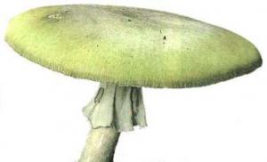
The nature of Eastern Siberia is mostly represented by taiga. Such vegetation extends for hundreds of kilometers from the Lena River to the Kolyma. In the south, the taiga borders on the local possessions are untouched by man. However, due to the arid climate, the threat of large-scale fires always hangs over them. In winter, the temperature in the taiga drops to -40 degrees, but in summer the figures often rise to +20. Rainfall is moderate.

Also, the nature of Eastern Siberia is represented by the tundra zone. This zone is adjacent to the Arctic Ocean. The soils here are bare, the temperature is low, and the humidity is excessive. Flowers such as cotton grass, gravel, poppy, saxifrage grow in mountainous areas. From the trees of the region, one can distinguish spruces, willows, poplars, birches, pines.
Animal world
Almost all regions of Eastern Siberia are not rich in fauna. The reasons for this are permafrost, lack of food and underdevelopment of deciduous flora.
The largest animals are Brown bear, lynx, elk and wolverine. Sometimes you can meet foxes, ferrets, stoats, badgers and weasels. Musk deer, sable, deer and bighorn sheep live in the central strip.
Because of the eternally frozen soil, only a few species of rodents are found here: squirrels, chipmunks, flying squirrels, beavers, marmots, etc. But the feathered world is extremely diverse: capercaillie, crossbill, hazel grouse, goose, crow, woodpecker, duck, nutcracker, sandpiper, etc. .